A blog about a hike across Scotland (and possibly other things)

Month: April 2018

Horseshoe crab voyeurs

April 29, 3018


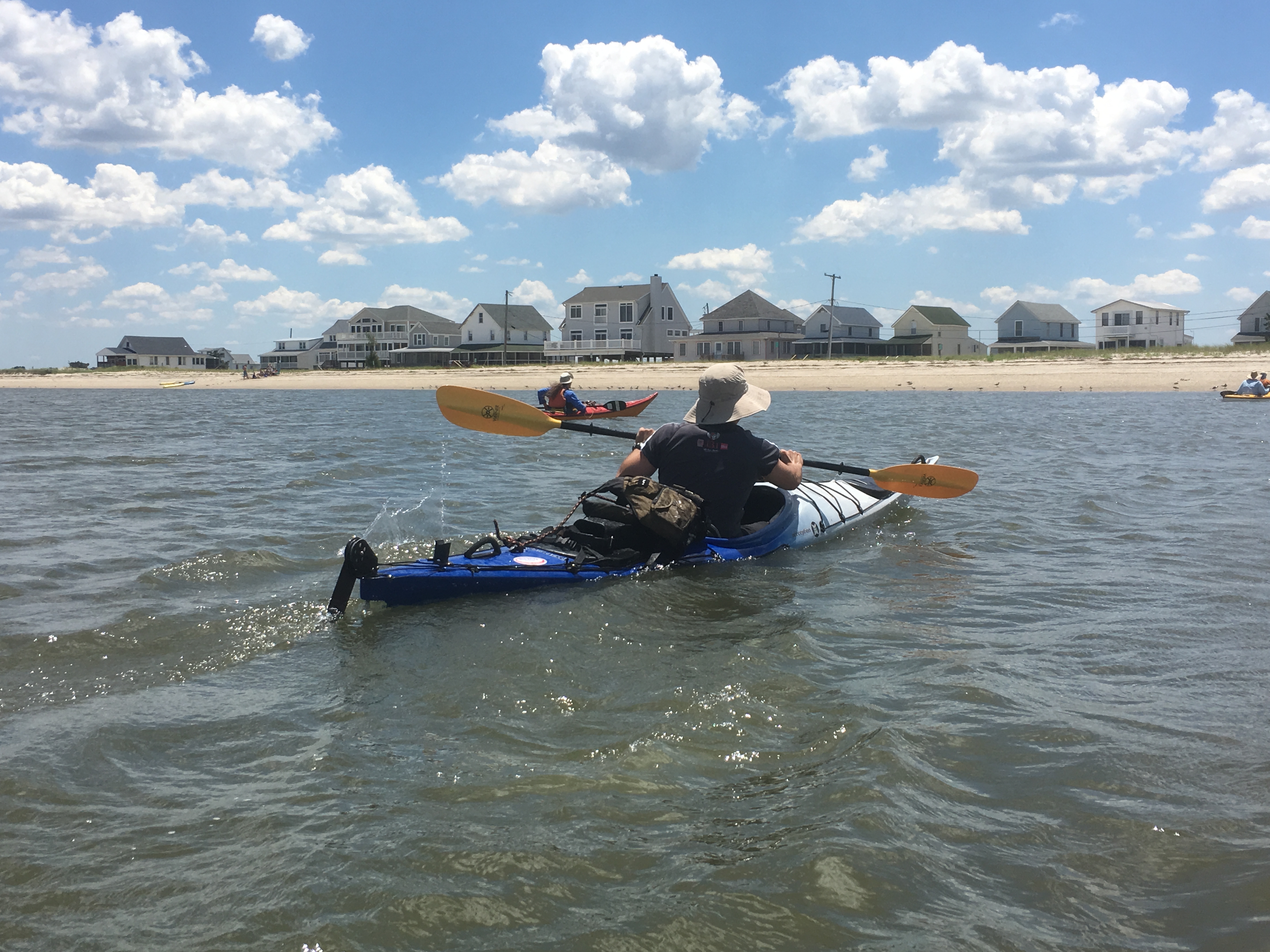
The water was high, but not so high that we couldn’t get under the Frederica Road bridge with anything more than a duck of our heads as the just-turning tide carried our kayaks toward Delaware Bay.

It was a spring tide in late spring. We were an armada of 15 boats. We were here to watch what happens when the full moon calls to one of its oldest listeners.

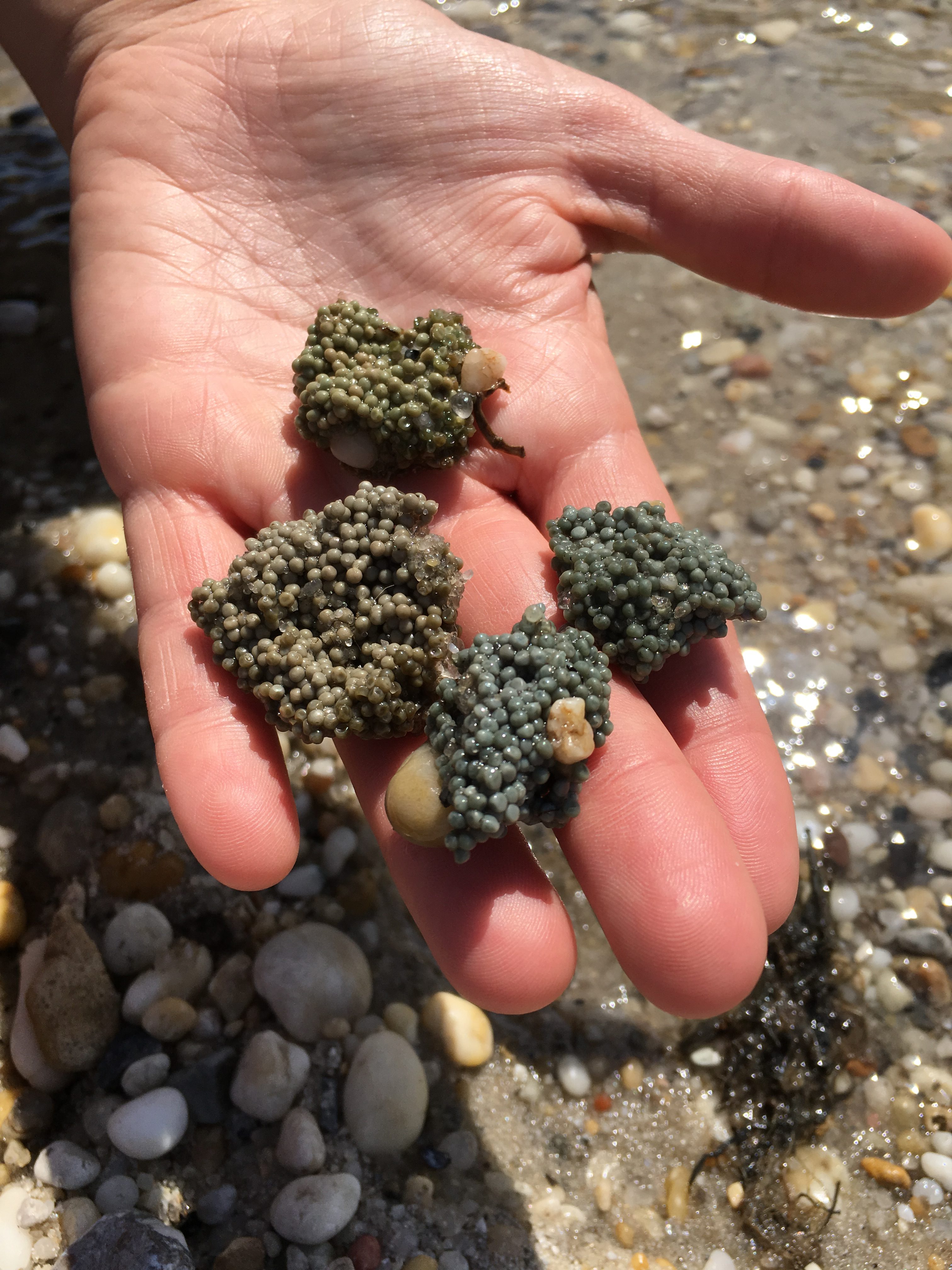
Each May and June, millions of Atlantic horseshoe crabs come ashore along the East Coast to spawn. The invasion is most dramatic when there is a full moon or new moon, creating the highest tides of the month. When it’s over, the beach is littered with the helmet-shaped shells of the Atlantic horseshoe crab, Limulus polyphemus, and trillions of its greenish eggs.

While these animals spawn from Maine to the Yucatan Peninsula, Delaware Bay is the center of activity. Exactly why isn’t certain, but warm water and sandy shores without big surf are part of the reason. Some swim and crawl more than 60 miles – from the continental shelf off the mouth of the bay – to get there.

We came farther to see them.

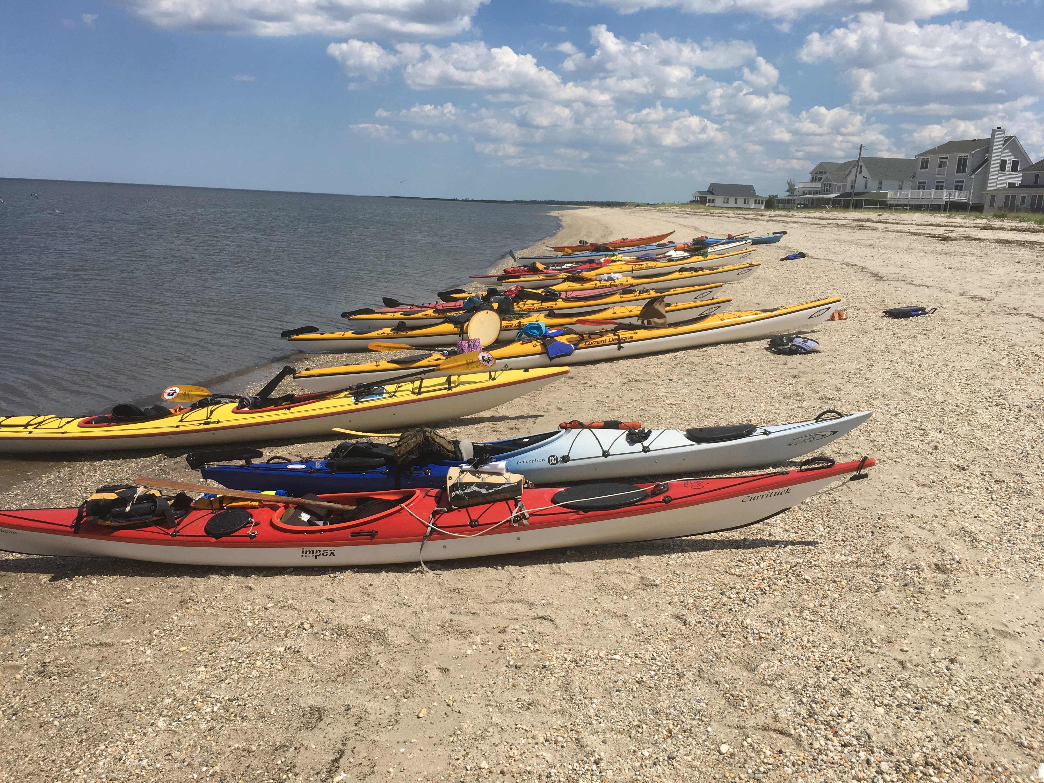
Thirty of us, from New York, Philadelphia, Baltimore, and Washington, spent three days and two nights on the Delaware side of the bay on a trip run by Upstream Alliance, an environmental education nonprofit in Annapolis. It’s not a trip you can duplicate exactly (more on that later), but a destination worth getting to nevertheless.

The group included numerous people from places upstream of the bay, including a legislator and a staff committee director from the Pennsylvania General Assembly, an official of the Camden County, N.J., parks department, and an executive of Philadelphia’s William Penn Foundation. They were curious about the condition of an estuary fed by a once notoriously polluted river.

How polluted did the Delaware River used to be? In 1943, Pennsylvania’s governor loudly complained that his state’s National Guard had embarked for Europe from New York, not Philadelphia.  The reason: the Navy refused to send vessels up the Delaware because of its corrosive effect on hulls.

Today, the Delaware River is not what it used to be. What it empties into – Delaware Bay – is no longer the stinky little sister to the Chesapeake Bay, which is five times larger and one peninsula to the south.

Delaware Bay is a gem hidden in plain sight.

The Murderkill River (roughly, “muddy river” in Dutch) carried us to the bay through a marsh in the full flush of spring.

On one bank the empty seed heads of wild rice stood above the new growth, while on the other bank the feathery tops of the reed Phragmites fluttered. Where the bank was higher, cedars grew. Red-winged blackbirds flashed their shoulder patches, and a pair of ospreys rubbernecked us as they glided overhead.

Soon we passed through Bowers Beach (pop. 360) with just enough time to exchange greetings with diners on a restaurant balcony before the current swept us into Delaware Bay. In the distance, a half-dozen container ships were making their way northward to Wilmington and Philadelphia.

We came ashore on a beach just to the south to eat lunch. As we finished, a wooden boat appeared out of the distant haze. Don Baugh, our leader and the president of Upstream Alliance, identified it as the Maggie S. Myers, built in 1893 and Delaware Bay’s last oyster schooner. It was returning from a day of fishing for conch. But with a dirty hull, a furled black sail, and tattooed men stowing gear on deck, it looked like a pirate ship returning from a raid.

After a while we pushed off and headed south. Our leader had secured permission for us to camp on private land a few miles away.

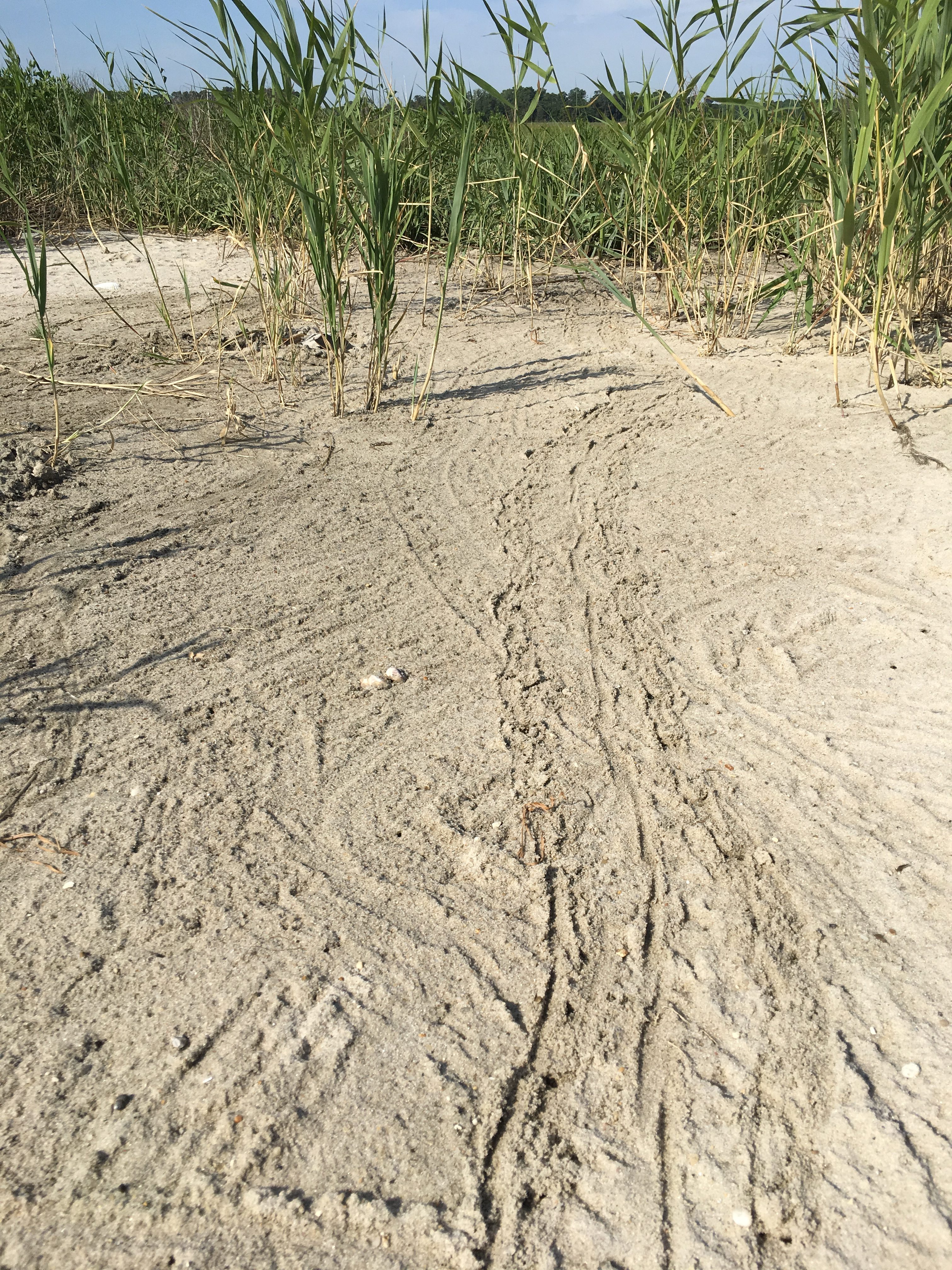
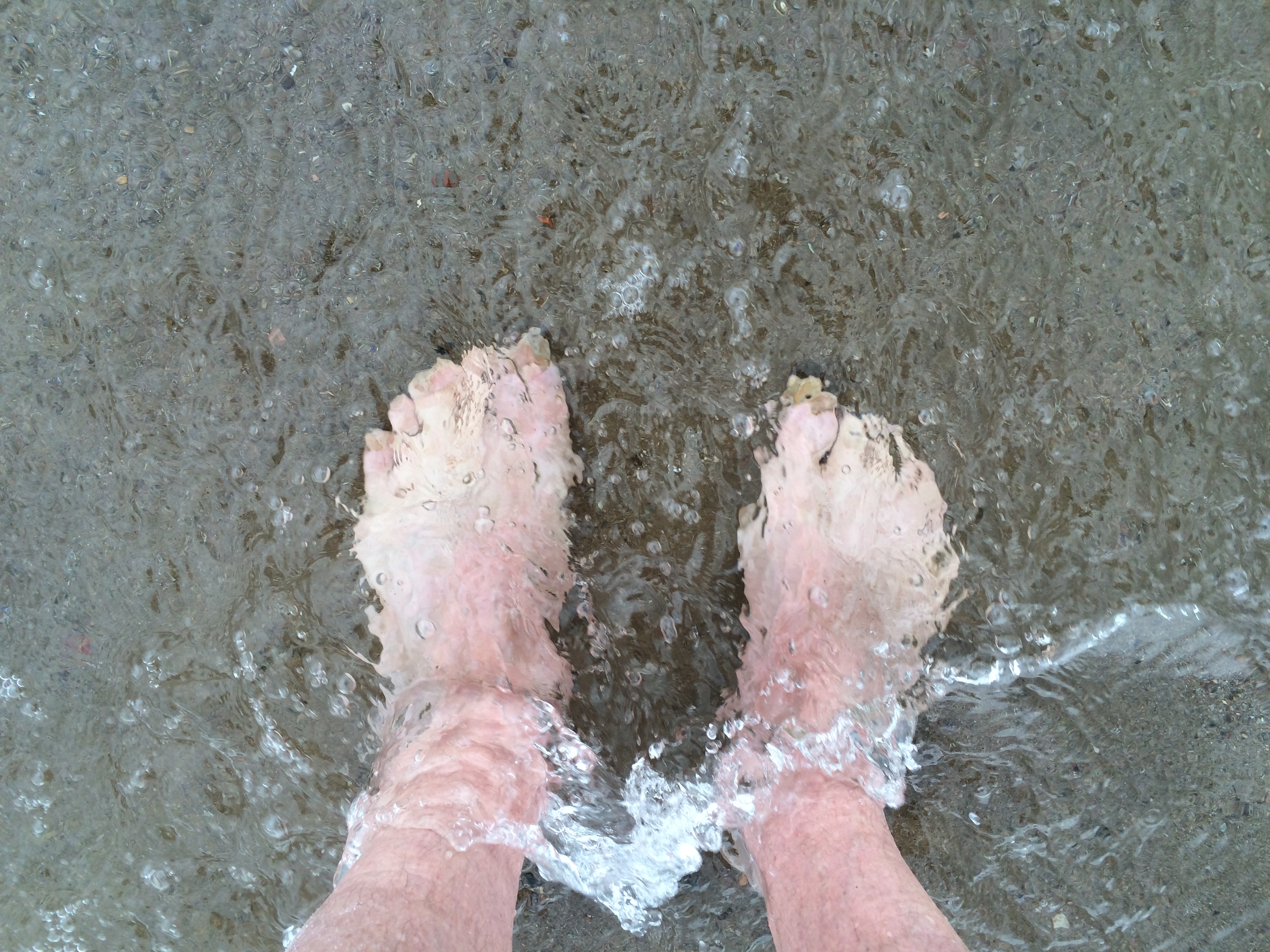
There, after setting up tents, collapsible tables and chairs in the hot sun, a few of us headed for the water for a swim. As we waded in, our feet bumped against – or were bumped by – things hard and rough. Soon it was clear that on the bottom was an invasion force of horseshoe crabs, lying in wait.

We’d stumbled into an underwater D-Day. Thank God for water shoes!

There was plenty of time to talk in the long pre-solstice evening before the moon’s pulling power brought the horseshoe crabs onto the beach. Much of the conversation was about water.

The people from Philadelphia noted that while the water quality of the Delaware River and its tributaries had improved greatly, that fact hadn’t made it into public consciousness. Swimming in any of the city’s waters was illegal, except for organized events such as triathlons. Baugh said he’d been accosted by police while kayaking and told even that wasn’t permitted. “People are still turning their back on the water,” said Maggie McCann Johns, the Camden County parks official.

The bad reputation was understandable. A few decades ago, striped bass and shad wouldn’t swim past Wilmington because oxygen levels in the water were too low for survival. In the tributaries of the upper Delaware Bay, fish kills of a million or more menhaden occurred about once a summer.

“I can’t remember the last time that happened,” said Robin Tyler, an aquatic ecologist at the Delaware Department of Natural Resources and Environmental Control.

After dinner, Tyler (who has since retired), delivered a brief lecture on the history of bay cleanup after dinner. He said the Clean Water Act of 1972, and economic change, are the big reasons things are different now.

Kent County – the middle of Delaware’s three counties, and where we were camping – used to have four city sewage plants, and an equal number of cannery and factory outfalls. None of them did a good job cleaning their effluent.

Today, there’s only one “point-source” discharge in the whole county – a sewage treatment plant outside Milford fed by 500 miles of pipes and 85 pump stations. The water it discharges is cleaner than many of Delaware’s streams.

“Although we hear a lot about environmental degradation, I would say in the last 25 years things have gotten better out on these waters,” Tyler said.

By the time the lecture was over the moon had appeared, a pale disk on the horizon, then a bright orb in full geographic display. We sat around a bonfire until high tide, and then wandered down the beach to see what was happening.

We found a strange sight.

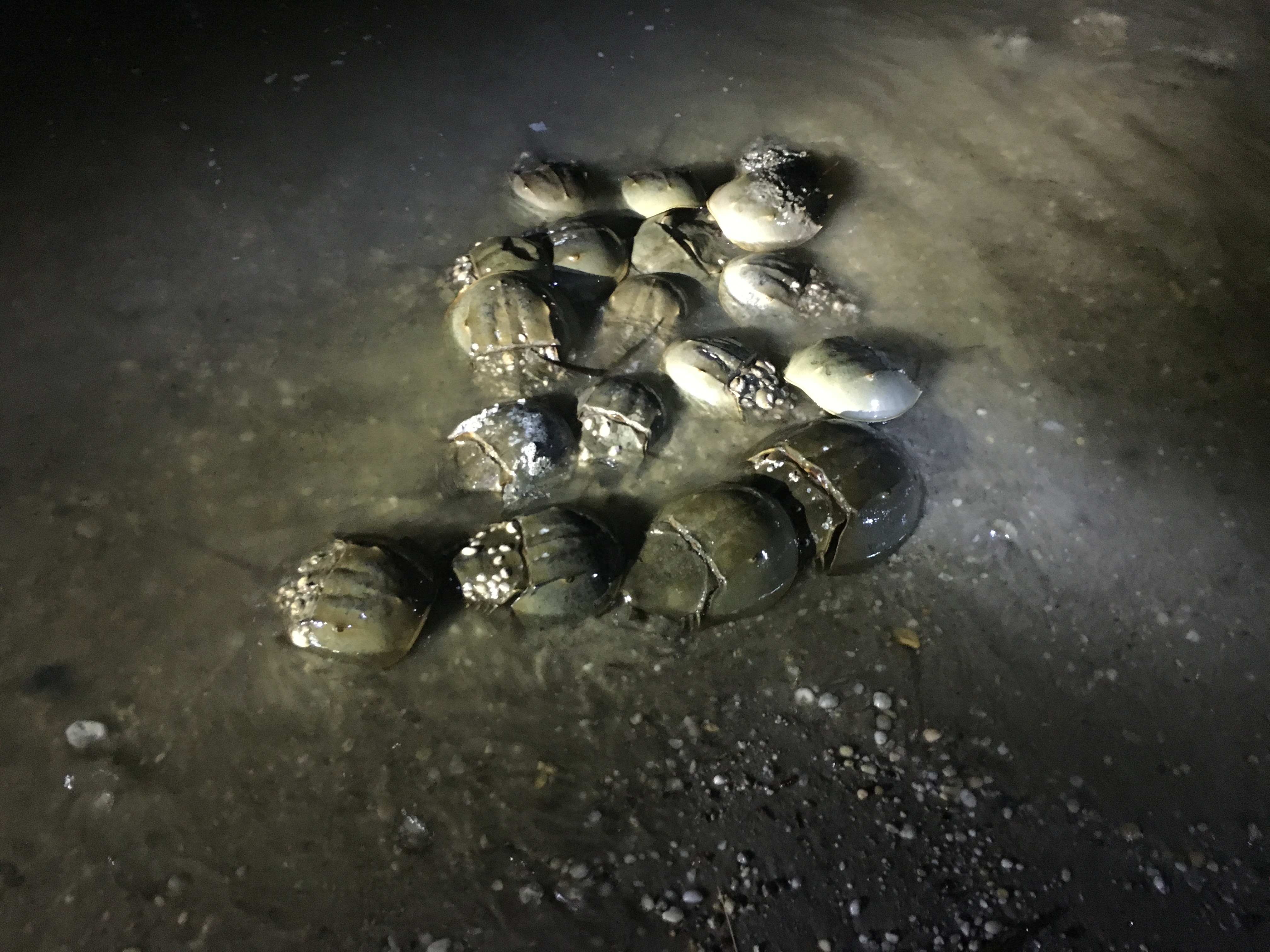
In groups separated by only a few feet, horseshoe crabs were swimming ashore, milling in the shallows, and climbing on each other. The females of the species are larger than the males, and the clusters of crabs often centered on a large individual, presumably a female. We checked a few – you can tell their sex easily by examining their forelegs – but in general didn’t disturb the foreplay.

Males can hold onto a female and ride her to the egg-laying site on the beach. A few had succeeded in this. Some females, however, were heading back to deeper water to shake their dates. Others were leading suitors in a conga line.

Round-backed and shiny, they looked like giant ticks, to which they are distantly related. Randomness and confusion was the order of the hour. It seemed an odd behavior for an animal that’d had 450 million years to perfect its mating dance.

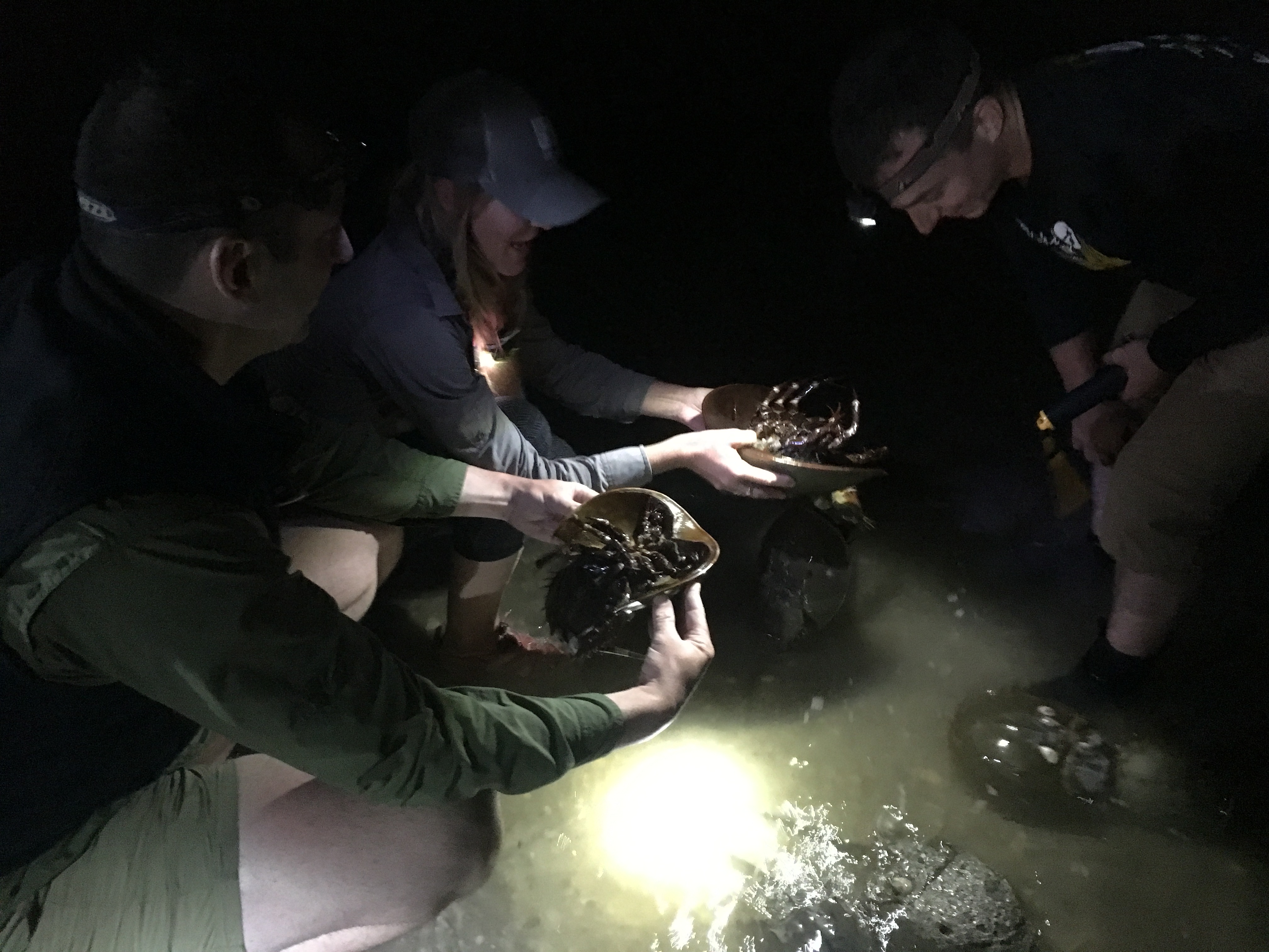
Alas, what they had to look forward to was underwhelming. There’s no actual copulation. Instead, horseshoe crab mating is glorified onanism. The female digs a small depression in the sand, deposits about 200 eggs, and the male on her back releases sperm onto them. The “satellite” males trailing behind then get their chance. In horseshoe crab society, the also-rans get a chance to procreate, too.

This mating ritual goes on several times a night. We watched by moonlight and flashlight, took pictures, and made a lot of off-color jokes. Someone said it was too bad we’d all be asleep when the crabs lay back on the beach at 3 a.m. and smoked cigarettes.

The next morning, I climbed out of the tent and took a walk. The sand was pockmarked with depressions and the marks of scrabbling appendages and digging tails. The shoreline was like a low-rent motel with an unmade bed in each room.  Housekeeping – the rising tide – wouldn’t be there for hours.

Horseshoe crabs are said to be “living fossils,” but that’s not quite true.

They’re related to trilobites, which lived 550 million years ago, and have existed as a distinct species for at least 450 million years. But they’re not unchanged. A fossil found in England from the Silurian period (425 million years ago) revealed an animal with more legs than its modern descendants.

The animal’s utility to human beings has also evolved.

From the 1870s through the 1930s, up to five million horseshoe crabs a year were collected and ground up for fertilizer and animal feed. That use ended in the 1960s. But in the 1980s a new harvest began as they were caught for bait for eel and conch traps.

In the 1990s, scientists noted a decline in the numbers of red knots, a migratory bird dependent on refueling on Delaware Bay’s horseshoe crab eggs on its flight from South America to the Arctic. (These days, about 45,000 red knots stop; they can double their weight in two weeks.) Reasoning that overharvesting might be responsible, the federal government created a reserve off the mouth of Delaware Bay where horseshoe crab harvesting is prohibited. That was followed in the early 2000s with a shortening of the season, and then a two-year moratorium.

At the moment, the Atlantic coast quota for horseshoe crabs is about 1.6 million animals. (Only males can be taken.) The Delaware Bay quota is 500,000. How much of the population is that? It’s hard to know, but a mark-and-recapture project in 2003 estimated there were 20 million spawning crabs in the bay that May.

A whole new use for Limulus polyphemus emerged in the 1970s when the Food and Drug Administration licensed a medical test that employed horseshoe crab blood as its main component. The blood coagulates on contact with endotoxin, a biochemical component of certain bacteria, including many that cause disease. The blood-based test is used to detect contamination in injectable drugs and on surgical implants. People who get hip replacements can include horseshoe crabs on the list of beings to thank.

Coastwide, about 600,000 horseshoe crabs are captured, scrubbed, and bled each year. About one-quarter of the animal’s blood is collected. The procedure kills about 15 percent of them, “and there may be sublethal impacts like failed spawning,” said Stewart Michels of Delaware’s Division of Fish & Wildlife.

Spawning appeared to have its own mortality, judging from the beaches we paddled past the next day. Many horseshoe crabs were lying upside down, their stiletto tails (called telsons) standing vertical. I learn later that they are not dead, just stranded and folded in a position that protects their gills.  (Turning them over or carrying them to the water, not by their tails, may save them). Nevertheless, from a distance they brought to mind battlefield graves marked by a gun stuck on its bayonet.

As we headed south on the bay’s western shore, we passed Big Stone Beach. It has one of the few remaining World War II-era “fire control towers” on the Delaware shore. Their purpose was to help direct artillery fire on enemy ships (which, of course, never appeared). Caught at the right angle, it looked like an upright, three-tooth jawbone.

Soon after, we headed offshore to get around a jetty built at the mouth of Mispillion River to protect a prime spawning beach behind it.  A pair of dolphins passed us, also heading south.

We spent the night on a sliver of private property inside Prime Hook National Wildlife Refuge – another stretch of beach available only to people with connections. As we wandered down to the water near midnight, the horseshoe crabs were out in force once again. But there was less pursuit and little mounting, and in truth they looked a bit tired.

We headed back north the next morning. As we tucked into the Mispillion River to go to the takeout, we came upon a muddy delta with hundreds of horseshoe crabs mating in broad daylight. They clunked and rumbled against the hulls of the boats. Modesty, it seems, wasn’t key to surviving 450 million years.

I’m not worried about their future. Fifty percent of Delaware’s bay shore and 25 percent of New Jersey’s were judged “optimal” or “suitable” for spawning in 2010 – an amount unchanged since 2002. (Hurricane Sandy, however, did considerable damage to the New Jersey side in 2012, reducing habitat suitability by 30 percent.) What’s problematic is public access to the Delaware Bay shore. While significant stretches are publicly owned, there’s no place for people to primitive camp as we did, without making special arrangements.

The horseshoe crabs can come ashore for a good time. Why not the bipedal primates?

NOLS for olds

March 22, 2018


In the 14-day sailing course run by the National Outdoor Leadership School, students take the helm the first day. (David Brown/For The Washington Post)


Eight days into a two-week sailing course in New Zealand, I felt like the young and ineffectual officer in “Master and Commander” who ends his troubles by jumping off the ship holding a cannonball.

Over the course of the day in an otherwise beautiful place, I had made a half-dozen mistakes. When we shortened the mainsail, I failed to recognize the tack — a grommet at the corner of the sail — for the first reef. I asked how to read the jib’s telltales, something we had been taught three days before. One time, I wrapped the jib sheet on the winch counterclockwise, the opposite of the way it should go. In a man-overboard drill, it took me three tries to snag a life ring named “Frank” with a boat hook as one of my fellow students, with great effort, got me within reach.

Maybe I was too old to learn to sail, I thought to myself after we rafted up with our companion boat at a mooring ball at the end of the day. I badly wanted a beer, but had to settle for one more cup of tea as I and the rest of the crew retreated below deck to review each others’ performance.

Sailing once was an important occupation in America; in 1870, 1 percent of working men were sailors. Today, it’s entertainment. People are born into sailing by proximity to water, wealth or an antiquated view of a well-rounded education. I learned to sail at a summer camp in the 1960s. It was kind of like learning to swim.

I knew, however, that real sailing wasn’t holding the tiller of a 10-foot dinghy. Real sailing happened in boats with keels and sails so big you couldn’t control them just by hand. It involved knots, lore and history. I had the sense, too, that real sailing was more than work or play. It was also a cramped and dangerous version of life.

Last fall, I learned that the National Outdoor Leadership School — an organization headquartered in Wyoming with branches around the world — offered a two-week, learn-from-scratch sailing course in New Zealand. Most students at NOLS are in high school and college. This one, however, was for “adults,” which at 65 described me well. I didn’t have a moment to lose. Plus, I’d get to see one of Earth’s most exotic places.

In one of the periodic sessions to review my progress during the course, the instructor, a 49-year-old Australian named Stephanie, brought me to the foredeck late one afternoon. We sat in the sun. A few days had passed since my day of mistakes, but I was still discouraged. She stopped me as I recounted my deficiencies.

“Instead of learning to sail three hours a week over nine months, we do it in two weeks,” she said, stating the obvious. “It’s hard work, confusing and overwhelming. But we find it works.”

She was right, as she was in just about everything on board.  And you can even learn to sail.

Cass, a New Zealander back home after years of itinerant teaching, explains the physics of sailing.  (David Brown)


As its name suggests, NOLS is a school. It’s not an outfitter or a guide service. (Although, it resembles them in certain ways.) It teaches backpacking, rock climbing, sea kayaking, sailing and skiing at 17 locations, among them India, Tanzania and Chile. The courses last from one week to five months; some colleges give credit for them.

In addition to outdoors skills, NOLS aspires to teach more abstract ones — judgment, self-awareness, clear communication, tolerance for adversity and other traits of good leaders. It contends that a group of people working together has needs, like an individual, and is nourished by healthy “expedition behavior.” NASA routinely sends new classes of astronauts on NOLS trips, so I knew this would be an ambitious course in a beautiful place.

That place was the Marlborough Sounds, a ragged collection of straits, channels, reaches, bays, inlets and islands at the north end of the South Island. The sounds open onto Cook Strait, the notoriously rough passage between the South and North Islands. Across it and out of view lies Wellington, New Zealand’s capital.

We sailed on two chartered Marconi-rigged sloops, one 35 feet long, the other 39. They had diesel engines, the usual electronics and self-furling jibs. Nothing fancy. The group consisted of nine students (six men, three women), two instructors and one instructor-in-training — six people on each boat.

Stephanie had sailed everything, including stripped-down racing yachts, tricked-out catamarans, a schooner taking naturalists to Antarctica and the 143-foot replica of British Navy Lt. James Cook’s HM Bark Endeavour. She’d worked for NOLS part-time for 18 years while teaching elsewhere, on and off the water, around the South Pacific. As of mid-November she’d spent five weeks at home in the year.

Her fellow instructor, a 38-year-old New Zealand woman named Cass, was similarly itinerant. Since 2003, she’d led expeditions in nine countries. Between courses, she explored on her own, staying with friends and relatives or sojourning in hostels and hotels. She’d just moved back to New Zealand. “It’s been almost 15 years since I paid rent,” she said at one point.

They knew everything about sailing. Their judgment was good. They never sidestepped a teachable moment. They were patient and indefatigable. They showed that, despite heroic efforts to shoehorn it into a curriculum, leadership is best taught by example.

They also embodied the truth that sailing is one of the few activities in which unrelated adults can tell each other to do things without decorous preliminaries, including saying “please.” This could be jarring at times.

There were other things to get used to as well.

NOLS likes hardship. If there’s a difficult or old-fashioned way to do something, NOLS will choose it. This builds character. Up to a point, I agree.

The course forbade alcohol. This wasn’t a surprise, even though it was an adult course, not one for high school or college students. We had to leave our cellphones on shore, which was good for all sorts of reasons. The boats had handheld showers in the heads, but we didn’t use them because we were conserving water. To freshen up, we swam off the boats at the end of the day. The water was in the mid-60s, which made this form of hygiene extra virtuous.

The food, however, was bad.

NOLS outfits its courses as if they all took place in the Wind River Range in winter. We had pasta, white potatoes, sweet potatoes, quinoa, rice, oatmeal and flour. We made bread, scones and muffins. We had vacuum-packed tuna that smelled like cat food and vacuum-packed beef that looked like dog treats. Our weekly vegetable-and-fruit ration for six people consisted of three onions, two heads of garlic, one cabbage, one pumpkin and a dozen apples and oranges. But it was late spring in New Zealand. Berries were coming into season. There were greens galore!

I have a friend who wrote a book about Martin Frobisher’s search for a Northwest Passage to China in 1576. I consulted him about the rations for that Arctic voyage. They included oatmeal, “wheat meal,” “biscuit bread,” dried peas, rice, salted beef and “stockfish.” Elizabethan sailors would have been right at home on a NOLS trip.

There was one thing I wasn’t prepared for, although maybe I should have been.

For people my age who aren’t already sailors, the most consequential nautical decision they’re likely to make is what size cabin to get on a Viking cruise. I realized that my $5,619 bill was for tuition, not a vacation. Nevertheless, I thought there might be a few other late-life novices. There weren’t. I was twice the age of the other students.

Dennis, recently off a 700-mile hike on the Pacific Crest Trail, shoots a bearing with a compass. (David Brown)


So, all you Sunfish sailors may be asking, what’s so hard about sailing a 35-foot boat?

I’m a (nonpracticing) physician and I can best describe it this way: It’s the difference between doing a finger-stick to check a patient’s blood sugar and putting a central line into his subclavian vein.

Learning to sail, in fact, is a bit like learning medical procedures.

Both require doing things in a specific sequence (and not being able to consult a cheat sheet while you’re doing them). They demand that you know what’s happening to objects — lines threaded through mast and boom, needles, guide wires and catheters — even when you can’t see them. Both favor “situational awareness” and decisiveness, and punish dawdling. Both are done in front of an audience — the patient or the crew — and can do damage.

One secret of NOLS’s pedagogy is that it lets students do things before they are competent or confident, but always with an observer ready to step in and help. That’s similar to the “see one, do one, teach one” culture of medicine — learning in which there is little actual teaching.

Students each day held one of five roles — mate, engineer, steward, navigator and navigator’s assistant. While the mate’s job was the most demanding — deciding when to raise and shorten sail, taking the helm for docking and mooring — there was no place to hide in the rotation. Every role was essential. The navigator and assistant, for example, were responsible for planning the day’s passage, marking it on the chart, estimating distances, informing the person at the helm of landmarks and hazards, and recording speed and position in the log.

But it wasn’t all work.

One day, we were catching 25-knot gusts on whitecaps at the edge of Cook Strait. People were getting worried as the boat heeled over more than it ever had before. “Let the boat tell you what to do,” Stephanie said in an uncharacteristically Zen pronouncement. A little while later, two members of the crew, simultaneously and unprompted, let out whoops of delight. Everyone else joined in, thrilled by the forces we had, for the moment, harnessed.

And then there was New Zealand all around us.

Although the South Island is temperate, not tropical, the forests are jungle-thick. The treetops are so tight against each other that the land appears to be clothed in a sweater of nubbly yarn. Many of the trees are exotics I’d never heard of — tree ferns, tea trees, cabbage trees.

The fauna was pretty exotic, too.

Four times, we encountered Hector’s dolphins — a small, rare species. We got into a pod of bottlenose dolphins, one of which probed the rudder with its snout. We sailed past blue penguins. When we went ashore one afternoon to talk about changing the crews, a flightless bird called a weka wandered out of the woods and started foraging on the beach. It’s in the rail family, whose American cousins are among our most secretive birds. In New Zealand, they don’t seem to have gotten the message that human beings could be a problem.

Marlborough Sounds is far from being the most isolated part of New Zealand. But it still offers visitors a sense of discovery.

At the place where one of the waterways, Queen Charlotte Sound, meets Cook Strait, uninhabited islands and rock formations rise out of the sea. We sailed near them one day. I looked toward the North Island. The land was out of view, but hovering over it was a cloud bank that stretched along a tenth of the horizon.

This is what the Polynesians saw. Their name for New Zealand — the Maori name — is Aotearoa, which means “long white cloud.”

Sarah, an urban planner from Denver, paid for the course with an education award she earned from a year of work with AmeriCorps. (David Brown)


Sailboats are famous for not wasting space, and sailors are famous for keeping the space tidy, but there’s no getting around the lack of privacy.

I slept on the banquette and table in the “saloon,” the common area below deck. The phone booth-sized head opened into this space. At night, a stumble going topside was likely to wake the whole boat. But we all got used to it, and to each other.

It helped that, the first week, we gathered around the table after dinner and told our stories. This was both bonding and entertainment.

For me, it was also a view on millennials, a chance to hear about other roads taken by people who were the age of my only child.

When I learned that my fellow students were all Americans no older than 30, I figured they might be preppies right out of a Vineyard Vines catalogue. I couldn’t have been more wrong.

Five of them were paying for the course from AmeriCorps education awards —$5,900 tuition vouchers earned by 10 months of subsistence-wage service work. The best student among us had gone to a vocational college and was a diesel mechanic. One student had lived three months in a house without electricity or hot water during her senior year in high school. Two weren’t college graduates.

They brought a cornucopia of experience. One had already been a foster parent. One was a former massage therapist, now working for FEMA. One had just come off 700 miles on the Pacific Crest Trail. One had learned rudimentary plumbing and wiring while putting up low-income housing in Utah. One was an actor who’d worked in a fish-cleaning plant in Maine; he regaled us with accent-perfect stories.

Stephanie, the Australian instructor, held us rapt one evening describing a trip on the tall ship Endeavour.  The vessel, with a 56-person crew, was sailing off the west coast of Tasmania. In that part of the world, the fetch—the distance wind can blow over water without being obstructed by land—is essentially the circumference of the planet.  The seas were so big it took two people to turn the ship’s wheel.

On every swell, Stephanie and her partner surfed the ship diagonally down the wavefront in order to keep the bow from submarining. At the trough, the masts nearly disappeared from view.  As the following swell lifted the boat, they straightened it (“two spokes back on the wheel”) until it was perpendicular to the crest.  Every swell took concentration.  She did this for two hours.

“It was a lot of fun. But tiring,” she said modestly.

These device-free evenings connected us with a seafaring tradition — long monologues. We were like Joseph Conrad’s Marlow telling the story of Lord Jim or the doomed voyage from “Youth” (although we lacked the cigars and claret.) The evenings were one of the best things about the course.  And age didn’t matter.

Students calculate the route and distance of the next day’s travel as part of “passage planning.”  (David Brown)


Two weeks goes faster than you think. There were life lessons right up to the end.

On the last day, the wind died. We had a schedule to keep, so we motored. Not wanting to waste a final teaching opportunity, Stephanie cut pieces of cord and showed us how to make Turk’s heads, a form of decorative rope work often used as bracelets.

We all sat in the cockpit twisting and weaving the line. I had a hard time doing it as soon as I took my eyes off her demonstration.

“Let me guess which way it goes next,” I said, trying to lure her over for help.

“No guesswork. Just do it right,” she said curtly.

I thought of something Clifford W. Ashley (1881-1947) wrote in his famous book of knots: “A knot is never ‘nearly right’; it is either exactly right or it is hopelessly wrong.”

Stephanie took about a dozen turns out of my work. It was a while before she got things straight and could proceed.

“Bit hard, isn’t it?” she said, as much to herself as to me.

A bit hard. Yes.

We can be thankful that life is more forgiving than sailing, and sailing is more forgiving than knot-tying.  Also, that it’s never too late to get better at all three — and practice helps.

Just-in-time paleontology

March 11, 2017


At first, the bones are hard to see in the chunk of fused pebbles that Patrick Sena is holding. But in a minute they appear: a piece of jaw with a yellowing tooth, and a bleached femur whose round end could hide under the head of a pin. They’re 28.5 million years old.

Sena, a paleontologist with the San Diego Natural History Museum, looks up and squints at a hillside in the distance where scrapers and front-end loaders are noisily working. In a few years, these 250 acres will be Otay Ranch Village 3, with 1,200 dwelling units, an elementary school, a park, a swim club, and industrial and commercial spaces. Whatever Oligocene treasures the land may hold — other than the inconsequential ones in Sena’s hand — will be beyond reach.

For the next few weeks, however, the hunting will be good. Sena hopes to bag fossil tortoises, camels and rhinos, along with numberless small carnivores like the one whose bones he’s holding. “They will be cutting down through the richest part of the Otay Formation. That’s why I need to be out here.”

It’s the law. It’s also a terrific deal for the San Diego Natural History Museum, which gets to keep whatever is found.

In California, when governmental agencies, developers and even private landowners dig in fossil-rich soil, a paleontologist must keep an eye on the work. Since 1995, Sena’s museum has provided this service for a fee, competing with private scientific contractors. Any significant fossils that are found must be curated, catalogued and transferred to a museum or university, although in certain circumstances landowners can retain ownership.

This arrangement has filled the San Diego museum’s display cases as well as its coffers. In fiscal 2016, the museum’s PaleoServices business provided $1.35 million, roughly 12 percent of the institution’s operating revenue, and salvaged specimens now make up 75 percent of the institution’s fossils. This win-win arrangement may be unique among American natural history museums.

“I don’t know of any other museum doing it the way San Diego is,” said Scott Foss, senior paleontologist at the U.S. Bureau of Land Management in Washington.

“They have the perfect combination of lots of construction, the need to mitigate, expertise and the ability to display,” said Kirk Johnson, director of the Smithsonian’s National Museum of Natural History.

Other museums have occasionally struck arrangements of the sort that San Diego has institutionalized. For example, the Denver Museum of Nature and Science made about a half-million dollars from survey-and-salvage contracts for interstate road projects in the 1990s, said Johnson, who worked there at the time. More often, the museum did consulting work for free. When construction at a resort uncovered skeletons of mammoths and mastodons in 2010, the museum hustled to raise $1 million to recover them.


At a Chula Vista, Calif., construction site in 2000, workers from the San Diego Natural History Meseum’s PaleoServices unit excavate the fossilized skull and vertebral column of a whale that lived about 3.5 million years ago. (Courtesy of Thomas Deméré)

There’s a long history of salvaging fossils from construction sites.


In 1673, a London apothecary and amateur archaeologist, John Conyers, found a tusk of an extinct elephant-like animal during work to divert the River Fleet into an underground culvert. The specimen was eventually acquired by Hans Sloane, whose collection started the British Museum. In the United States, a mastodon skeleton was found in New York in a pit dug to extract limestone fertilizer. The discovery is depicted in Charles Willson Peale’s “Exhumation of the Mastodon” (1806-1808).


Thomas A. Deméré, the 68-year-old head of PaleoServices, is one of the founders of the field. He has a doctorate from UCLA and originally worked in the oil industry. (Fossils help identify geological formations that may hold oil.) He found a lot of great specimens but couldn’t publish anything about them because that might reveal petroleum formations to competitors. “Everything was a big secret,” he said. “It was kind of nonscientific.”

When local governments in Southern California started requiring protection of fossils in the 1980s, Deméré created Paleo­Services while also working part time at the museum. In 1995, the museum took over the company and hired him full time.

The arrangement has proved unusually fruitful for the 142-year-old museum, whose focus is the natural history of Southern California and Baja California.

In San Diego County, the geologic record is most complete for the past 75 million years, with the Pliocene (the past 4 million years) and the Eocene (40 million to 50 million years ago) especially well represented. A building boom that has lasted half a century guarantees there’s always lots of excavation to monitor.

Before the 1980s, the museum’s fossils came from around the world — a “stamp collection,” in Deméré’s words. The arrival of salvage paleontology, ironically, has made the holdings more scientific, allowing scientists to fill in many blanks in the region’s prehistory. The museum’s collection has 154 holotypes — the specimen from which a new species is described — and 50 of them were found in construction sites.

Mitigation paleontologists don’t gather up all the fossils that a road project or housing development uncovers. Instead, they collect samples while keeping their eyes out for marquee items, such as the 3-million-year-old whale skull found during the construction of a bike trail last fall.

The collection strategy is often “driven by a research question,” said Shelley L. Donohue, PaleoServices’ report writer. As an example, she cites the Sycamore Landfill, “a giant hole that will be filled with trash.” Seven years of digging has allowed scientists to answer hard questions such as how ecological niches were filled (or left empty) over the eons. At the moment, there’s a particular interest in insectivorous mammals.

PaleoServices field workers normally haul a ton or two of material away from a site in pickup trucks and sift it for fossils. Occasionally, dump trucks are used. The museum collected 25,000 pounds from one place in the 1990s, looking for prosimian primates, which it found.

This moveable feast of fossils means there’s plenty of leftovers. Surplus specimens are given to schools and even to visitors. A construction site in Chula Vista yielded a load of sand dollars, shells and bird bones. Children were allowed to screen the material and keep what they found.

About a dozen researchers visit the museum each year to use the collection. About 50 papers, from both in-house and outside scientists, have been written based on the museum’s holdings in the past 30 years.

There is a downside, however, to collecting fossils with construction equipment.

“The paleontological monitor noticed an explosion of white when the road scraper tagged that,” Deméré says, pointing to the upper foreleg — the humerus — of a Columbian mammoth now awaiting curation back at the museum’s lab. There’s an unnatural flatness to the end of the bone. The missing piece — a bulge called a condyle — was the price of discovery.

In an exhibit of marine mammal fossils, the top of the skull of an extinct gray whale is prosthetic. Another whale skull is missing part of its underside. The chances of a big, display-worthy piece of skeleton being recovered undamaged are pretty small.

The people at the museum call it the “scraper tax.”


Collection’s manager Kesler Randall and curator Thomas Deméré work together with staff at the Naval Medical Center San Diego to place the partial skull of a Columbian Mammoth (Mammuthus columbi) into a CT scanner. (Robert Rutherford/San Diego Natural History Museum)


In San Diego County, a paleontologist must be present if construction at a fossil-bearing site will move more than 2,500 cubic yards of soil. At Otay Ranch Village 3, 7 million cubic yards will be moved. Pat Sena, who is 48, is going to be there awhile.

Bulldozers and road scrapers — four and eight of them, respectively — were shaving the top off a ridge on this particular day. Their target was a layer of volcanic ash called bentonite, which is a poor material to build houses on. Dump trucks deposited 28,000 cubic yards of the material down in swales at the bottom of the hill each day.

This was once a coastal marsh, with braided streams flowing into a sea. Deluges scoured deep channels. Heavy material from uphill and inland — including the bodies and bones of living things — were deposited there. Most of the skeletons in the museum’s collection are incomplete because the animals weren’t buried where they died. The few terrestrial dinosaurs in the collection bear evidence of having been washed into the ocean. An ankylosaur (armored dinosaur) and a hadrosaur (duck-billed dinosaur) each have oyster shells stuck to their fossil bones.

The excavated ground at Otay Ranch is a mixture of clays and cobbles in gray, white and tan. It’s hard to make out the walls of the ancient channels unless you know what to look for. Sena does. He started young, accompanying his geologist father on outings to search for uranium deposits, work that involved well-logging — recording characteristics of geological formations.

“While he would be well-logging, I’d be collecting fossils. I used to carry a geology book around with me in first grade,” he said. “Nothing’s changed.” A former corpsman in the Marines, he joined PaleoServices 20 years ago. He doesn’t have a college degree. What he does have is an eye for small objects, up close and at a distance.

“He can find fossils where nobody else does. He sees patterns. He just has a feeling for the earth,” Deméré said.

The law requires that grading be suspended “upon discovery of fossils greater than twelve inches in any dimension.” There are few discoveries that big. When there are, they’re removed en bloc, field-jacketed in plaster and taken back to the museum for definitive uncovering.

Such rules sound like a recipe for endless delay, but apparently they aren’t. “Very rarely do we have to move out of an area for any length of time,” said Lance Dougherty, the jobsite foreman for the company shaping the land at Otay Ranch. “Sometimes it’s an hour, sometimes it’s half a day. It doesn’t slow us down because we can work in another area.” He acknowledged, however, that it’s sometimes inconvenient.

For his part, Deméré knows that keeping fossils safe isn’t a high priority for government.

“Obviously, there’s a cost associated with regulations. There’s a cumulative effect when you stack them all up. But I’d hate to see us take a big step backward.”

As a way to thank property owners, builders, excavation contractors, bulldozer drivers, environmental planners and city staff, the museum holds an annual party to display what has been collected in the previous year.

“The idea is that, without mitigation work, all this would be lost — everything from bison heads and whale jaws to mice teeth and tiny shells,” Deméré said.

“One of the showstoppers last year was fossilized foraminifera,” said Donohue, the report writer. “You have to see them through a microscope,” she said of the tiny calcificed organisms.

Some property owners don’t need thanking. During the construction of a high-rise at Thomas Jefferson School of Law in downtown San Diego, equipment operators found a mammoth, a gray whale and a shell bed in sequential strata. “The dean was thrilled. He is a history buff. And Jefferson collected fossils,” Deméré said. The parking levels under the building are named for the discoveries at each depth.


PaleoServices monitors discovered this skeleton of a 3 million-year-old fish during trenching excavations for a sewer line. (Antonio Cusumano/San Diego Natural History Museum)


Paleontological digs are famously slow operations. Scientists sprawl on the ground, uncovering objects with dental picks and sable brushes as if they had all the time in the world.

Salvage paleontology is different. It’s more closely related to chain-saw sculpture and speed chess. And birthday mornings.

In the trailer at Otay Ranch, the project superintendent, Robert Greninger, sat at a desk beneath a map of the development. The house lots on its not-yet-built curving streets look like the vertebral bodies of long-necked, long-buried lizards.

When Deméré greeted him, Greninger mentioned the 10-year-old son of his boss.The boy loves visiting the site. But it isn’t to see the machines with eight-foot tires. It’s to see “what Mr. Pat has found.”

Of such encounters are paleontologists born.

Kayaking around Manhattan

September 7, 2017


Kayakers approach the lower end of Manhattan on the Hudson River, where One World Trade Center dominates the skyline.  (David Brown)

The Hudson River has always seemed like a trench filled with water, its bottom a Stygian tangle of sunken boats and discarded equipment, its water an over-steeped tea somehow brewed from the lives of 8 million people.  By the same token, Manhattan seemed less an island than a moored raft covered with concrete, asphalt, steel and well-tended plants.

So when I eased myself into a kayak one day this summer to start a paddle around Manhattan Island, I was surprised to see a little beach nearby. Water came up from depths onto a patch of sand, with weeds just beyond. It was the geological past sticking its nose out from under 400 years of human occupation.

Circumnavigating New York City’s core by water combines nature’s forces with man’s work in a way that’s as dramatic as any place in America. It’s also a trip strangely poignant and evocative, even for someone with no New York roots or even much knowledge of the city’s history. And the funny thing is, it’s not even that hard.

Each year, the Yonkers Paddling and Rowing Club sponsors the “Manhattan Circ”— a trip around Manhattan Island in kayaks. This year, 158 people from 12 states and two foreign countries (Canada and Spain) did it. One-third were women; only one person dropped out.

To participate, you have to apply, attest to your skills, be accepted, and pay $80. Of course, the logistics are considerable if you’re an out-of-towner, what with getting a kayak into the country’s most densely populated place and finding somewhere to stay. But it’s worth it.


I went with a group of people affiliated with an Annapolis nonprofit organization called Upstream Alliance. The Inwood Canoe Club, on the Hudson in far northern Manhattan, kindly allowed us to store the boats overnight and launch from its docks. The Circ’s organizers had divided the fleet into three groups based on anticipated speed; two of the groups launched a few hundred yards from us at a public beach on Dyckman Street.

The Inwood is the only survivor of a string of boat clubs that once lined that part of the island’s shore. Founded in 1902, and the home of seven Olympic canoeists in the middle of the last century, it recalled an era when New York’s waterways were more recreational than they are today, and perhaps cleaner and less intimidating.

The day and hour of the Circ are chosen so that tidal flow will assist participants as much as possible. As we paddled into the eastern edge of the Hudson’s channel, it was immediately clear this would not be a trip for the inattentive. The flow was swift. The river was in full ebb, doubling our paddling speed toward the Battery, the southern tip of island, where we would catch the flood tide that would carry us up the East River.

The group I was in would, in theory, be the fastest of the three. A motor launch appeared on our right. It accompanied us the whole way around, keeping us from straying into the all-business middle of the channel, like a border collie herding a flock of aquatic sheep.

The overcast sky hid the tops of the George Washington Bridge’s towers. We paused briefly just above the bridge and then proceeded under it. A rumbling filled the air and disappeared. White, balloon-shaped buoys — presumably for transient yachts — strained against their mooring chains, the dark water pillowing over them. They were the first of several not-so-obvious obstructions we encountered that could easily have flipped a boat. (Thankfully, none did).

Paddlers pass under the Queensboro Bridge. (David Brown)

On my deck I had an old National Geographic map of Manhattan that I’d cut up and had laminated and spiral bound. It helped me get a rough idea of where we were as we hurried down the West Side on an eight-knot express. I spotted Grant’s Tomb, the Riverside Church, and later the Empire State Building peeking out from the island’s interior. As the haze cleared, the morning sun silhouetted rooftop water tanks, making them look like little party hats. In the afternoon on the East River, I recognized the United Nations headquarters, which in my 1960s childhood was second only to the Statue of Liberty in recognizable New York landmarks. (Such a hopeful time!)

Early on we passed a gigantic concrete structure with half-moon fenestrations lining its waterside front. I asked a fellow paddler what it was and he said it was a sewage plant. To be precise, it was the North River Wastewater Treatment Plant, which processes 125 million gallons of sewage a day and stretches from 145th Street to 137th Street.

Despite being surrounded by it (and partly because of that fact), water has always been a problem for Manhattan. New York City residents consume 1.3 billion gallons of clean water a day (imported from far north of the city), and dispose of 1.4 million gallons of liquid waste. The water was once notoriously polluted, and by a century ago had wiped out commercial fisheries of shad, clams and oysters while spreading cholera, typhoid fever and other fecal-oral illnesses.

Joseph Mitchell, the New Yorker magazine’s famous chronicler of the city, started a 1951 article called “The Bottom of the Harbor” this way: “The bulk of the water in New York Harbor is oily, dirty, and germy. Men on the mud suckers, the big harbor dredges, like to say that you could bottle it and sell it for poison.”


Things are better now. Thousands of people swam in the Hudson the day after the Circ as part of the New York City Triathlon. The Billion Oyster Project is engaging schools (among other groups) to restore New York’s oyster grounds. There were 220,000 acres when Henry Hudson navigated the waters in 1609; the project so far has restored a little more than one acre and planted 22 million oysters. Heavy rains occasionally overwhelm the wastewater treatment capacity, spilling coliform-laden water into the rivers. We got occasional whiffs of sulfurous sewer gas on our passage.

We stopped at Pier 40, at West and Houston streets, in Greenwich Village, where people looking for a bathroom could admire the watercraft in the Village Community Boathouse. It promotes the construction and rowing of dory-like boats of a century-old design called “Whitehall gigs”— one of many examples of how New Yorkers are again turning to the water for recreation.

We approached the Battery with the Statue of Liberty and Ellis Island in the distance to our right, and One World Trade Center on our left. The waterway here is New York’s aortic outflow — high-pressure, turbulent, essential. The Circ organizers arranged for us to cross it in 15-minute windows that would keep us safe from the gigantic, orange Staten Island ferry and its wake. By then, our group had caught up with the second-fastest one. We watched its paddlers cross as we milled around near a barge in a man-made cove — in this part of Manhattan, everything is man-made — waving to pedestrians on the waterside promenade.

Eventually, we got the signal to cross. This required hard, no-nonsense paddling. (I was chastised by one of our chaperons for pausing to take a picture.) At one point, we had to hold up unexpectedly to avoid a tour boat. As we headed into the East River, the water became a hectic mix of standing waves, wakes and clashing currents. Nobody appeared to be giving us much quarter. We were like mice crossing a crusty field of snow, hoping not to be picked off by predators.

Safe on the Brooklyn side, we caught our breath and headed up the East River under the Brooklyn, Manhattan and Williamsburg bridges. We passed the blackened stubs of old dock pilings, shuddering in the current like loose teeth.

We paddled the length of Roosevelt Island and at its far end came ashore at a beach in the Astoria neighborhood of Queens. We tarried there until the tide became favorable. Because the beach would flood, we carried the boats — the entire fleet, as the three groups were now together — up the street to Socrates Sculpture Park, a four-acre outdoor museum built on an old landfill. There, an overworked food truck, a small farmers market and a performance of Bengali music and dance entertained us for nearly two hours.

We crossed to the Manhattan side of the river at the lower end of Hell Gate, the most notorious strait in New York’s harbor and the site of uncountable shipwrecks over the centuries. The water was slack; our timing was right. We paddled right over the spot off East 90th Street where the excursion steamer General Slocum, carrying 1,400 people — most of them recent German immigrants — caught fire on June 15, 1904. The death toll of at least 1,021 would not be exceeded in a single disaster in New York until 9/11.

At the north end of Randalls Island, we turned left into the Harlem River, where we were favored by the tidal quirk that makes the circumnavigation such a winning proposition. The tide pushes water that is already in the Harlem River northward, as well as pushing water that is not already in the Harlem River into it. One wouldn’t think it possible! But it happens twice a day.

(Here, it’s worth noting the distance around the island was 30 miles, which we covered in 6½ hours of paddling time. Our average speed was just under 5 mph and our maximum speed an astonishing 8.7 mph. An oceanographer in our group calculated we did the work of a 20-mile paddle at 3½ mph. In other words, one third of the distance we covered was entirely thanks to tide and river flow.)

Paddlers head down the Hudson River, with Lower Manhattan in the distance. (David Brown)

While people came from many places to do the Circ — I paddled on and off with two guys from Los Angeles — there were enough from New York to provide a guided tour for the curious and sociable.

A paddler pointed out the garbage pier, the air vent for the Holland Tunnel and a row of Trump Organization-built apartment buildings recently stripped of their builder’s name. Another told me as we passed under the Queensboro Bridge that it was also known as the 59th Street Bridge. (“Are you feeling groovy yet?” he asked.) I learned about Marble Hill, the Manhattan neighborhood that is no longer on Manhattan Island, thanks to rerouting of the Harlem River at the northern end of the island in 1895.

I was instructed to note the Pepsi-Cola sign in Long Island City in Queens, a landmark that’s both pop-cultural and nostalgic-industrial. From my reading of the aforementioned Mitchell essay, I pointed out to a fellow circumnavigator that the eddies at the bend of the East River between the Manhattan and Williamsburg bridges is where corpses that go into the water in the winter frequently surface in the spring.

We paddled under more than a dozen bridges; Manhattan is an island, after all. The oldest is High Bridge, opened in 1848 to carry the Croton Aqueduct that supplied water to the city. Macombs Dam Bridge (1895), near Yankee Stadium, with its stone piers, pyramid-roofed shelter houses and steel camelback in the middle, is my new favorite.

As the Harlem River got narrower and more industrial, culminating in the ship channel of Spuyten Duyvil, I was amazed to see a rocky outcrop on my left, the very northern tip of the island. I paddled over. It was shaded by vegetation growing out of its face and vines hanging down from its top. The air was laden with the smell of moss and mold. I thought to myself: “This, at least, is unchanged. This is something the Lenape Indians and the Dutch colonists might recognize.” Then I thought about the blasting it took to make the ship channel. “Maybe not.”

The rivers the Circ followed were pretty much where they’d been in 1600. The currents and tides were the same (and so, undoubtedly, were some of the water molecules). Flowing water was the changeless New York City, and I’d been looking at it all day.

Time travel at the Penitentiary

January 14, 2016


Interior walkways inside the Eastern State Penitentiary. In the travel industry, prison museums are a growth sector. (David Brown)


I was halfway down Block 1 at Eastern State Penitentiary in Philadelphia, peering into a cell for a thief imprisoned in 1829, when I realized the place resembled a Carthusian monastery.

Members of Catholicism’s most austere order, Carthusian monks live, eat, work and sleep alone in “cells,” coming out only for church services and a four-hour walk each week. They are forbidden to speak unless given permission. Each man has a tiny walled yard where he can look at the sky and feel the sun. As the wonderful book “An Infinity of Little Hours” (2006) makes clear, it’s a life balanced between sanctity and madness.

In the first era of Eastern State’s 142-year life as a prison, inmates spent 23 hours a day in their cells, with two half-hour recesses in private yards reached by a stoop-through door. Their only reading material was the Bible, and they spoke to no one but guards and the chaplain. If they left their cells, they were hooded. Some spent years inside the massive stone walls without seeing the face of another prisoner.

Today, it seems odd that this was ever viewed as a way to cure antisocial behavior. But it was. In fact, the “Pennsylvania system” was penology’s breakthrough idea, rescuing murderers, burglars, forgers and confidence men from cruel treatment by keepers and fellow miscreants. Eastern State, the idea’s embodiment, went on to be the model for 300 prisons on four continents.

Seeing how “penitence” got into the word “penitentiary” is just one revelation that awaits a visitor to Eastern State Penitentiary, surely one of the country’s more unusual museums.

In the travel industry, prison museums are a growth sector. A book published last year, “Escape to Prison:  Penal Tourism and the Pull of Punishment,” looks at 10 of the roughly 100 of them around the world. Although some (like Alcatraz, or South Africa’s Robben Island) are better known than Eastern State, few can compete with it.

“In its educational and historical narrative, it’s clearly at the top,” said Michael Welch, the Rutgers University sociologist who wrote the book. “It’s not a theme park. It’s not intended to amuse you.”

It is, in the words of Steve Buscemi, who narrates the indispensable audio guide, “a magnificent ruin.”

The architecture is Gothic Revival, with 30-foot walls of Wissahickon schist, faux battlements and two gargoyles over the entrance holding lengths of chain. Inside, the walls are flaking paint and spalling rock dust. Birds swoop in and out of broken windows. Vines and saplings have taken up residence where prisoners worked and lived.


In the Eastern State Penitentiary exercise yard, a sculptural graph shows U.S. rates of imprisonment over time. (David Brown)


One of the prison’s innovations was its hub-and-spoke design, which is still used in many prisons. Cellblocks radiate from a central rotunda, where guards kept watch. Seven blocks are open to visitors, and hundreds of cells have been left as they were when their occupants moved out in 1971, down to tipped-over stools and open drawers.

Guides are stationed around the prison and the grounds. (Several I spoke to were recent Temple University history and archaeology graduates.) They give mini-tours to parts of what was essentially a walled town forced to evolve without changing its footprint.

“Soup Alley” is a covered walkway with cafeteria counters on either side, built in 1924, when inmates started eating together. A stove with an oven door open is covered with dust near where a tarred roof has collapsed. A dining room, created by knocking down the walled yards of the nearby cells, stands empty.

Part of Cellblock 3 was converted to a hospital in 1880. A tree root snakes over the door to the operating room, added in 1910. Inside, a steel IV pole sits in a corner and a surgical lamp the size of a searchlight hangs from the ceiling. Al “Scarface” Capone, who spent time at Eastern State in 1929, had two operations there. One was a tonsillectomy; the other, unnamed, was probably a circumcision. (Capone had syphilis, and circumcision would reduce the chance he’d transmit it.)

It’s remarkable that people are allowed in such places in this era of phobias over lead paint, trip hazards and things-you-may-have-to-duck-under. The museum shows respect for the good sense of its visitors, who numbered 194,000 last year (30,000 in group tours).

The idea for a new kind of prison originated at a meeting of the Philadelphia Society for Alleviating the Miseries of Public Prisons in 1787. (Benjamin Franklin was an early member.) Inspired by Quaker ideals and Enlightenment thinking, the prison was designed to induce regret and penitence in prisoners. It was more than 30 years before the Commonwealth of Pennsylvania took the suggestion. Eastern State Penitentiary opened its gate in 1829.

The corridors and cells have vaulted ceilings that suggest an ecclesiastical setting. The single skylight in each cell was called an “eye of God.” The food was reputedly good. Pipes under the floor delivered central heat, and bucket-flush toilets connected to a sewage system. This was a time, the commentary points out, when the White House had neither of those amenities.

However, not everyone agreed that solitary confinement was the route to reformation. Charles Dickens toured the penitentiary in 1842 and wrote: “I hold this slow and daily tampering with the mysteries of the brain to be immeasurably worse than any torture of the body . . . it extorts few cries that human ears can hear; therefore I the more denounce it, as a secret punishment . . .”

The “Pennsylvania System” of solitary confinement didn’t last long. As early as the 1840s some prisoners had cellmates, and in 1913 the strategy was abandoned. New multi-tiered cellblocks were squeezed in between the original ones. By the 1920s, the institution built for 700 inmates housed 2,000.

The walls are flaking paint and spilling rock dust inside the Eastern State Penitentiary, which opened its gate in 1829. (David Brown)


A cell at Eastern State Penitentiary, which was designed to induce regret and penitence in prisoners. (David Brown)


The place is so big and operated for so long that the opportunities for narrative are legion. And the museum takes full advantage of them.

There are displays about women prisoners (who were there until 1923), race in prison, prison gangs and famous inmates. You can see the restored synagogue, Capone’s cell and the place from which 12 people, including the bank robber Willie Sutton, escaped (temporarily) through a tunnel. A dozen cells have been given over to artists for installations. On display now is a reconstruction of a cell from Camp X-Ray at Guantanamo Bay. Another, called “Other Absences,” has pictures of 50 men, women and one child murdered by former inmates hanging from the ceiling of two cells.

What wasn’t addressed for years, however, was the growth of imprisonment in the United States, a trend known as mass incarceration.

“There was this massive blind spot,” said Sean Kelley, the director of interpretation and public programming who was the museum’s first full-time staff member in 1995. “The old ending of the audio tour asked people to reflect on the current incarceration system. But we didn’t give them any facts on which to reflect. It was essentially the same as saying, ‘Drive safe.’ ”

Today, the facts are hard to miss. They take the form of a $100,000 sculpture erected in 2014 in the center of the exercise yard.


The corridors and cells in the Eastern State Penitentiary have vaulted ceilings that suggest an ecclesiastical setting. (David Brown/For The Washington Post)


For every decade since 1900, the number of people imprisoned in the United States per 100,000 population is depicted as a steel box of proportionate height. Through 1980 the rate varied from 100 to 200. Those boxes are a couple of feet high; you could step from one to the next if they let you. Then the rate took off. In 2010, it was 730 per 100,000, and the box is 16 feet tall. Viewed from other angles, the 3-D infographic compares the U.S. imprisonment rate with that of other countries, and it also depicts the racial breakdown of the American prison population over time.

The museum is finding other ways, as well, to engage the subject of crime and punishment.  On the first Tuesday of each month, a scholar, author or public official gives a talk in the rotunda, followed by a reception.  September’s speaker, the Philadelphia Police Commissioner Charles Ramsey, was shouted down by Black Lives Matter protesters.

Eastern State Penitentiary, too massive and obsolete to be repurposed after it closed, has found new life helping people, once again, think about the purpose of imprisonment. Its long-dead founders would be pleased.

Hillwalking across Scotland

 September 26, 2015

Loch Calavie, a small lake near Scotland’s west coast where the author camped alone on a gravel beach. (David Brown/For The Washington Post)


Two ridges of heather and grass rosed up on either side of a narrow lake, like weathered hands scooping a drink of water.  The blue sky was furrowed with clouds as bright as the patches of snow on the mountains in the distance.  A gravel beach, wide enough for a few tents, etched a parenthesis in the distance.

It was my first day out on a walk across Scotland, and I’d stumbled upon one of the most beautiful camping spots I’d ever seen. As I pitched the tent and made dinner, the light fading with arctic slowness, I kept hoping somebody would arrive to share the place with me. But nobody did. It was all mine, for better or worse.

That’s how it was for much of the next 13 days. Backpacking across Scotland, if you go alone, as I did, is an exercise in beauty, solitude and expectancy.

I made this trip in May as part of an annual event called The Great Outdoors Challenge. Named for the British outdoor magazine that sponsors it and organized by a small army of volunteers, the Challenge helps about 300 people traverse the country, from west to east. The hikers (or “Challengers,” as they call themselves) don’t all take the same route, or even a few established ones. There are no equivalents of the Appalachian Trail or the Pacific Crest Trail to follow. Instead, they custom-build routes from local hiking trails, farm and forest roads, ATV tracks, military roads built in the 18th century, and drovers’ and hunters’ trails that are even older.

Everyone leaves from one of 13 designated starting places on the west coast and finishes 13 or 14 days later on the east, traditionally by wading into the North Sea. They then make their way to Montrose, a seaside town where a celebratory banquet is held in a hotel.

You have to apply, pay a small fee and convince the organizers you’re fit before you’re accepted into the Challenge. The chief advantage of participation is the advice provided by a dozen veteran hikers, who review and approve every route — more than 200 different ones this year. These experts tell you which footbridges have been washed away, what streams are too dangerous to ford after heavy rains, where the good camping spots are, what sights not to miss.

My route was about 200 miles long. Even though it took me to a B&B or hostel about every third night, I was mostly on a camping trip — and a long one. I had to carry what I needed on my back, and be prepared for anything, including snow.

There are easier ways to hike in Scotland. The Challenge is simply an extreme version of what is Scotland’s national pastime: “hillwalking.” The country’s Outdoor Access Code allows people to walk and pitch tents on both public and private land. (There are a few exceptions, such as the British royal family’s Balmoral Estate.) All a walker has to do is stay away from crop fields, animals and buildings.

I walked 10 to 17 miles a day, with each day’s uphill sections averaging about 2,000 vertical feet. It took a lot of planning and was hard enough that I took an unscheduled rest day halfway through. But the payoff was huge. There aren’t a lot of places where you can walk sea-to-sea across a country that is beautiful, exotic and English-speaking. Scotland is one.


Although many people follow a route by GPS on a handheld device for the Challenge, carrying paper maps is also strongly advised. (David Brown)


I flew to Glasgow and took a train to Strathcarron, my starting point. It’s a hamlet at the end of a finger-shaped “sea loch” consisting of a hotel and two blocks of whitewashed houses.

That part of Scotland is the same latitude as southern Alaska, so only a few weeks before the summer solstice, daylight wasn’t going to be a problem. I couldn’t say the same for the 40 pounds on my back. As I headed down the road and then into the hills on the first morning, I excused the weight by telling myself I had seven pounds of electronics — I was writing a blog — as well as four days of food. Over the next two weeks, however, I learned that some people somehow made the crossing with only half what I carried.

The Highlands were deforested centuries ago, which gives them a big-sky look that rivals Montana and Wyoming. But while lack of water shapes the American West, it’s the abundance of water that has made the Highlands.

It rains a lot. Sometimes for minutes, sometimes for days. The ground can be boggy even on hillsides, as hikers taking off-trail shortcuts soon discover. There isn’t a lot of bare rock (other than ruins of cottages) because things get grown over by moss, grass and heather. The end product of all the vegetation is peat, the Highlands’ wood-substitute. Huge banks of it sometimes erode into what look like surfable waves — frozen black fronts, topped with a grassy curl.


Ruins of tenants’ cottages fill the Highlands of Scotland. (David Brown)  


One advantage of all the water is that you don’t have to carry any. Wherever you are, there’s a cold, clear, drinkable stream within a hundred yards or so. Not to mention lots of lakes, such as Loch Calavie, the gem I stumbled upon the first night.

With few trees and no jagged mountains, the Highlands are hard to get lost in. Of course, it’s different if you’re in fog or a snowstorm, but luckily the weather was clear for most of my time there. The first four days I walked down valleys and over ridges, scattering sheep, rabbits and grouse, and seeing almost no one.

The emptiness lent sweetness to the moments when a person did appear on the path, offering a few minutes of conversation, an exchange of gorp or hard candy and, occasionally, hours of companionship. Hillwalking creates a fraternity even for solo walkers (which 140 of the 298 participants this year were). That, in turn, gives Challengers permission to inquire about a fellow walker’s life, and to synopsize their own.

If you don’t want company, you can just walk on, no excuses necessary. But if you do, the Challenge can become a Canterbury Tales of interesting characters and encounters.

I walked through a rare patch of forest in the drizzle with a 75-year-old retired surgeon — a woman — whose career had been solo gigs on Hebridean islands and other far-flung spots, filling in for doctors needing a break. I spent a morning with a woman my age — 60s — who told me about growing up in postwar England, where margarine and marmalade were rationed and her house had an outdoor privy. Nothing, however, epitomized trail society better than my day with Stevie, a 56-year-old paving contractor from a town south of Glasgow.


Stevie walking ahead.

I’d camped on the bank of the River Findhorn. Sheep grazed in a pasture that went up a ridge to where the umber heather began. I encountered Stevie when I got to the gate to the farm road that went up and over the ridge to a river valley 15 miles away. He was changing clothes and getting ready for a strenuous climb. Muscular and taciturn, he carried a backpack half the size of mine.

I thought about waiting, but I figured he’d be a fast walker, so I told him I’d see him on the trail. For the rest of the day we played tortoise-and-hare, catching and passing each other and exchanging snippets of conversation.

His father had been a bus driver, he told me, and his father’s father, too. He learned to love the outdoors when the family would rent a cottage in the mountains for two weeks in the summer and he would run around with his shoes off. From an aunt, he said, “I learned to love wild birds.” He described some he’d seen in the last few days, including the once-endangered red kite. He was married once (“it wasn’t for me”) and has no children (“my one slight regret”).

When he was young, he walked with his brother and a cousin. Often it was nothing more than “a rush to get to the next town and the next bar.” As he got older he went alone, often with only a rough idea of a route. A few days before we met, he’d gone over four 3,000-foot summits in a day, stumbling into his tent after dark with just enough energy to make tea before falling asleep.

Recently, however, he’d started enjoying the company of others. He’d walked with two Germans for a day early in the Challenge. When we got to Aviemore, our mutual destination for the day, he hoped to rendezvous with a woman he’d met on the walk the previous year. “I’m learning new habits,” he said with surprise in his voice.

Nevertheless, when he wanted to go on, he did. No waiting for the American with the obese pack.

By midafternoon I figured I’d seen the last of him until I got to a long abandoned stone cottage called the Red Bothy. In the lee of the building he was having a lie-down with his boots off. We chatted briefly until I said I had to get more miles behind me. He nodded understandingly: “You go’ qui’ a big ki’.” Quite a big kit— yes, that would describe it.

He caught up to me an hour later where the road went over a divide into the watershed of the snowy Cairngorm Mountains. We sat on stone pylons in the sun and looked back at a hill we’d come over separately in the morning. It seemed an impossible distance away.

“I like being in the moment,” Stevie said, getting suddenly philosophical. “But it’s on reflection that it’s frigging brilliant. In a few weeks you forget the pain and remember only the beautiful days. And this might be one of them.”

I couldn’t have agreed more.

We got up and walked, but this time he didn’t go ahead. We descended into Aviemore together and then went our separate ways.

I saw Stevie three days later in Ballater, my next village port-of-call. He and the woman he’d been hoping to meet were in a pub near my hostel, and he greeted me like an old friend. Which, in the strange time-dilation of the trail, I was.


Stevie looking back.

There are few obvious dangers on a wall across Scotland.  The Highlands require no technical climbing; the ground is padded like a gym mat; the spring and summer days are forgivingly long.  There are no bears and only one species of poisonous snake.  But that doesn’t mean there isn’t discomfort, as I found in the Cairngorms on the hardest day of my walk.

Like New Hampshire’s White Mountains, the Cairngorms aren’t terribly high, but they have harsh and changeable weather that is occasionally fatal to the ill-prepared and unlucky. At 2 in the afternoon, in the rain and with many miles already under my belt that day, I headed over one of the range’s plateaus to a place called the Fords of Avon.


For four hours I climbed a stony and windy trail that got stonier and windier the higher it went. Gusts staggered me. I ended up wearing almost all the clothing I’d brought — fleece, rain jacket, hat, mittens.

A peculiar attribute of Scotland’s round, bare hills is that you can rarely see the tops from below. What appears to be a summit turns out to be only the brow of a ridge, with another ascent beyond. That was the case on this climb. It seemed to go on forever.

When the ground finally leveled off, I estimated the wind was blowing about 50 mph and the temperature was in the high 30s. The grass tussocks were blown flat and the trail was littered with pink granite boulders. The descent, as I looked ahead, was going to have its own ups and downs.

When I got to my planned camping spot at 7:30 it was still raining, and blowing so hard it was difficult to pitch a tent. I was “proper knackered” — totally exhausted. Three or four tents were clustered around a wooden box one-third the size of a shipping container that serves as an emergency shelter for hikers and skiers. Inside, people were finishing dinner. Among them were two first-time Challengers — a 69-year-old nurse, Stella, and a 70-year-old retired professor of social work, Viv.


Stella and Viv

At some point in the evening, the conversation got around to why so many older people are eager (and able) to walk with a backpack for two weeks.  Of the 298 people who started the Challenge this year, only 30 didn’t finish.  The median age of participants is over 55 years, with a range from 22 to 85.  The theories offered were thoughtful and observant.


“There’s the ‘Rage, rage against the dying of the light.’ ”

“When you get old you have a kind of freedom. You stop being essential to other people’s lives.”

“In a way, you’ve got more stamina when you’re older. Or more determination and patience.”

“If you’ve gotten to a certain age, you’ve had all sorts of ups and downs. You have confidence that things will work out. That you’ll be warm and dry in the end.”

Which was all true, even that day.

Rapeseed and gorse.

Eventually, walking east, the land gets less wild, less hilly, less monochromatic. Lichen-covered ruins become rare, more towns appear, and there’s no avoiding paved road some of the time. Horses and cattle join sheep in the pastures. Fields of rapeseed and a thorny bush called gorse produce yellow flowers as bright as you’ll see anywhere.

Eventually you come over a hill and ahead see not more hills, but the North Sea.

As I descended the last hill to the town of Stonehaven, my route’s destination, I stopped to slip a bunch of empty food packages into a trash bin at the end of someone’s driveway. (It’s never too late to lighten the load!) A car coming up the hill stopped. I thought the driver might chastise me, but instead, he wanted to congratulate me (he’d seen other Challengers) and suggest I go to a particular fish-and-chips shop in town to celebrate. Which I did.

That night at the dinner in Montrose I sat across from a 31-year-old American woman who is an “ultralight” hiker. Her loaded backpack without food weighs 10 pounds. She carries no tent (only a ground sheet and tarp), no stove and a tiny sleeping bag. She hikes six months of the year, supporting herself with IT jobs in the offseason.

She couldn’t be more different from me. Yet in her desire to test limits in a beautiful landscape I recognized a kindred spirit.

At my age of 63, there are a lot of things that are no longer likely or possible. I’ll probably never go up Mount Kilimanjaro or run another marathon. I won’t spend a winter crewing on boats in the Caribbean. Won’t learn to play the piano. Might learn another language, although that’s a long shot.

But I’ll tell you one thing that is possible. You can walk across Scotland and put your feet in the sea.


Homer & Wyeth in the studio

November 20, 2014

You can’t tell much about a painter or a writer from the place where they painted or wrote. That’s true even when the wax apples and fruit bowl are still on a table, as in Cezanne’s studio, or the outline of a novel is written on the wall, as in Faulkner’s study.

Nevertheless, many people (and I’m certainly one of them) are moved by the chance to stand in the space where someone else’s brain, eye and hand created wonderful things. For lovers of American painting, there’s a chance to do that at two places within a hundred miles of each other on the Maine coast. The destinations are the Winslow Homer Studio, in Prouts Neck, 12 miles from Portland, and the Olson House in Cushing, south of the mid-coast town of Rockland.

Winslow Homer (1836-1910) made many of his narrative paintings (“Lost on the Grand Banks,” “The Gulf Stream,” “Fox Hunt”) and virtually all of his seascapes in the oceanside studio, in which he also lived for the last 25 years of his life. Andrew Wyeth (1917-2009) painted in the Olson House for 30 summers. Its occupants, an eccentric brother and sister, their farm and the building itself were frequent subjects of his paintings, most famously in “Christina’s World.”

Both sites were rescued from destruction or decay. The Olson House has been open to the public since 1993, the Homer Studio only since 2012. Each place reveals (and hides) its famous occupant in different ways.

A visit to the Homer studio requires planning, and in some seasons, patience. It is owned by the Portland Museum of Art, which runs two tours a day, each accommodating only 10 people at $55 a head.  When I first tried to get one, in August 2013, registration was filled six weeks out.

A van carries visitors from the museum to the studio, a 25-minute ride that allows the docent to describe how the Homer family came to buy land on Prouts Neck, the area’s history as a summer resort, and the six-year, $3 million rehabilitation of the studio.

Homer moved to the Neck in 1883 from New York City. His father and brother offered to provide him with a studio in the compound’s main building, called “The Ark.” Winslow, however, wanted his own place, and claimed the carriage house. He had it moved 100 yards away and closer to the ocean — a decision with both symbolic and practical effects. He also had a balcony, called the piazza, built across the entire water-facing side.


Homer was a bachelor, a dandy, an outdoorsman, an intermittent grump. Some scholars believe the trauma of the Civil War (which he’d chronicled as a newspaper artist) or unrequited love (of a woman or man) led him to an intensely private life. Whatever the reason, the studio has a monastic feel.

The big downstairs room is dominated by a fireplace in which Homer cooked some of his meals.  (Others he got from a nearby hotel by displaying a flag outside the house whenever he wanted a meal delivered.)  The walls are unpainted headboard.  The decor includes several dessicated and mounted fish skins.  There’s a hand-painted sign announcing the presence of snakes and mice, which he put outside to discourage visitors.

Upstairs is another large room, where he painted until a room for that purpose was added on the ground floor. There is no bedroom described or displayed.


Thankfully, visitors are allowed to linger on the piazza, with its view of rock ledge, ocean, islands and whatever boats may be passing by. It is from there a person can see a bit of what Homer turned into his famous “marines”–the paintings of crashing waves, anthropomorphic pillars of spray, weather-blown grass and bush, water and sky barely distinguishable from one another.

A webcam on the roof provides a daylight feed of the view to the lobby of the Portland museum.

Homer had a wonderful eye, and this place continuously beckoned it.

When a school of herring arrived offshore in the summer of 1884, he had a local boy row him out so he could watch fishermen hauling fish (“The Herring Net”). A decade later, he was sitting outsidethe studio smoking with a nephew one summer evening when he leapt up and said, “I’ve got an idea! Good night, Arthur,” according to one account. He painted until 1 in the morning and produced “Moonlight, Wood Island Light.”

But he wasn’t a literalist. It’s often hard to see the paintings in the landscape. “Cannon Rock” shows a piece of ledge jutting over the water and a wave breaking on an offshore bar. Those are events that occur at high and low tide, respectively, and thus never at the same time.

The tour, including the van ride out and back, takes 2 1/2 hours. It’s not enough time, especially at the price. The docent’s lecture and slideshow at the studio lasts too long; I wanted more time to explore both the house and the grounds.

That isn’t a problem up the coast at the Olson House.

Visitors may wander almost unrestricted through the 14-room structure, which is owned by the Farnsworth Art Museum in Rockland (which also has a large collection of Wyeth paintings). Weathered nearly black, it was built in the late 1700s, gaining its present appearance and a third story a century later. It’s a “saltwater farm” on a spit of land called Hathorne Point, although the water is less visible than it once was, and most of the outbuildings are gone.

Andrew Wyeth first visited the farm in 1939 on his 22nd birthday, brought by the teenage daughter of a family summering nearby. (They would marry the next year.) He also met Christina Olson that day and painted a watercolor — the first of 300 paintings he made there.


Olson had a neuromuscular disease that began in childhood. (It may have been Charcot-Marie-Tooth disease, and almost certainly wasn’t polio, as often claimed.) When Wyeth met her in her mid-40s, she couldn’t walk. Indoors, she transferred from chair to chair using her arms. Outside, she dragged herself over the ground, the strategy depicted in Wyeth’s most famous painting.

Both Christina and her brother, Alvaro — neither ever married — slept on the ground floor. The rooms above were unoccupied. Wyeth set up an easel in one of them and came and went as he wished. (His family had a summer house nearby). He painted some pictures of Christina and fewer of the shy Alvaro. His tireless models were the house’s rooms, the views out the windows, the battered exterior.

The kitchen and pantry today contain a few household objects and pieces of furniture. A poignant relic is a wooden dory in the loft of a shed attached to the house. Alvaro gave up lobster fishing when his sister’s disability became so severe that he had to be around during the day. The boat has never been moved, the docent said.

Most other rooms are empty. The house’s contents were sold at auction in 1968, although a few have since trickled back. Someone donated a rocking chair last summer.

What the Olson house displays is what can’t be taken away: the play of light on walls, the landscape seen through glass, the texture of worn wood and nubby plaster. They are among the things that make Wyeth’s art so memorable and moving. To stand alone in a room and look out the same window (different frame) he depicted in “Wind from the Sea” is to experience some of the “hair-standing-on-end” sensation he recalled he had upon opening the window one summer day in 1947.

What’s not obvious in the house (and even less in the pictures) is the inescapable fact that Christina and Alvaro lived in shocking squalor and poverty, even by the standards of rural Maine 75 years ago.

The house had no running water, and for most of the time the Olsons lived there, no electricity. There was no bathtub. A nephew recalls that the door into the kitchen left a four-inch gap to the outdoors, through which the winter wind howled. They burned 14 cords of wood a year, much of it stacked inside. Christina was incontinent and the house stank of urine. At the end of her life, there were too many cats.

Wyeth emphasized the Olsons’ dignity and self-reliance. Whether he owed them more is a matter of debate. He didn’t pay rent or modeling fees, but did sometimes cover bills at the general store. He stopped painting there in 1968 after Christina died. (Alvaro had died three weeks before her.) But he eventually returned.

At the family graveyard down the hill (that Christina may be crawling back from in “Christina’s World”), his is the first headstone you see.


Here are some photographs of the Olson House that were not published with the story.

The Olson House in Cushing, Maine.


The view approximately depicted in Andrew Wyeth’s most famous painting, “Christina’s World.”


Old front door, in front of which a road once passed.


The view of the house that is seen in Wyeth’s 1965 painting “Weatherside.”


Hops that are said to have been planted by Christina Olson still grow and flower each year.


View from the living room out to the front door.


View from the shed through the kitchen and pantry to the living room. Wyeth painted this door and one out of view to its left in the 1968 watercolor, “Alvaro and Christina.”


A window in the kitchen.


Another view of the kitchen.


The other door in the shed depicted in “Alvaro and Christina.”


Alvaro’s lobstering dory in the hayloft, reportedly never taken down since the day he put it there after giving up fishing to take care of Christina.  The door to the privy is on the left.


A rare (but allowed) view into the two-hole, outhouse-style privy.


Remnants of things pasted to the privy wall.


A close up, from long ago.


The window (not original) in the 1947 painting “Wind from the Sea.”


The 1947 watercolor “Third-Floor Bedroom.”


And the window today.


For most of Christina’s life the house was without electricity.


Washboard, blueberry rake, clothes wringer.


A Maine, summertime hint of Wyeth’s Chadds Ford painting “Groundhog Day” (1959).


Gravestone of Christina and Alvaro Olson, sister and brother.


Andrew Wyeth’s grave.

Deep in the heart of Big Bend

April 30, 2015


Awake long before sunrise for other purposes, I decided it was a good opportunity to check on Capella and the kids.

I was camped with friends in a West Texas arroyo on a gravel bed just wide enough for two tents. On either side of us were a jumble of limestone boulders and the cliffs they came from. In the distance were humpback desert hills along the Rio Grande.

The arresting part of the landscape, however, was overhead. It was the night sky alight with stars.

I took out my phone, fired up the star-finding app and pointed it in what I thought was the right direction. I dug out of memory the first lines of a poem by Edna St. Vincent Millay I memorized in high school.

See where Capella with her golden kids

Grazes the slope between the east and north . . .

Alas, I couldn’t find the “goat star” (as Capella is less romantically known). I had done so the night before. But it didn’t matter. Her light had traveled 42 years to reach Big Bend National Park, and there would be another chance. Back in the tent, a scrim of mosquito netting between me and the universe, I saw two shooting stars.

The Milky Way rises in Big Bend National Park. (Brad Goldpaint/Getty Images)


There are many reasons to visit Big Bend, which seems to announce, in true Texas fashion: “No need to go anywhere else; we have it all here.”

It’s big — bigger than Rhode Island. It’s empty, accounting for less than 1 percent of Americans’ 65 million visits to national parks each year. It’s dangerous; three hikers died of heat-related illness there in 2013. It has a world-class desert and river, three canyons, its own mountain range, more species of birds (450) than any other national park and 1,300 kinds of plants, most of which seem to be barb-protected.  People who saw last year’s Oscar-nominated “Boyhood” got glimpses of it late in the film.

It’s also the best place in America to fall asleep under the stars.

Over the past five years, Big Bend has eliminated or retrofitted the outdoor lights on the park’s 289 buildings, as well as in its parking lots and campgrounds. In 2012, it received gold-tier certification from the International Dark-Sky Association, based on five measures of nighttime darkness and clarity. Only 13 parks in the world have that designation. Big Bend shares with three other places the claim to having the least light-polluted sky in the Lower 48 states.

The time may come when star-gazing is Big Bend’s big draw. (The cover photograph of the official 2014 park calendar was the night sky.) Like most visitors, however, I went there for down-to-earth reasons.

A college classmate I saw at a reunion invited me to accompany him and a friend on a trip they take each fall to celebrate the friend’s recovery from a serious illness years ago. They have a fondness for less-visited national parks. At Capitol Reef in Utah, someone told them to try Big Bend.

Big Bend is nestled in the U-shaped dip of West Texas’s border with Mexico. The name refers to the curve in the Rio Grande, where the river’s flow turns from southeast to northeast. Getting to the park requires flying to the middle of nowhere, and then driving three hours.

“We’re not a place that you drive by and visit,” said Kym Flippo, one of the park rangers. “You either really want to be here or are really lost.”

We spent nine days in Big Bend, straddling the end of October and the start of November. We took two hikes separated by a sojourn in Terlingua (population 799), the nearest town. There, we stumbled into the preparations for two — two! — national chili-cooking contests, which turn out to be the big tourist draw in this part of the country.


The campsite on the Chihuahuan Desert. 


Even before the plane lands at Midland International Airport it’s clear what this part of Texas is all about. Oil-well pumps bob just off the runway, and inside the terminal the advertisements are for work gloves, pipe-threading, and “horizontal completions.” The one nod to non-working visitors is a billboard for the George W. Bush Childhood Home, open six days a week.

After loading up on food and fuel canisters — campfires are prohibited in Big Bend — we headed southwest toward the park. The road passed the King Mountain Wind Farm, 214 turbines on a mesa south of Odessa and evidence that fossil and renewable energy are sometimes bedfellows. Eventually, the half-prairie, half-desert landscape turned into hills and, beyond them, the pillared Chisos Mountains.

Big Bend National Park is a geological textbook. Its oldest rocks date from 500 million years ago. There are ancient sandstone and shale beds, and more recent fossil-bearing limestone. The landscape is carved by igneous intrusions, lava and ash from volcanic eruptions, and tectonic fracturing, uplift and erosion.

The 35-million-year-old Chisos Mountains, topping out at 7,825 feet, are topographical newcomers. (They are also the only mountain range contained entirely within a national park.) They have some features of Utah’s and Colorado’s mountains, but their distinguishing attribute is they’re in Texas. We were constantly running into Texans who couldn’t believe they were seeing their home state.

For our first hike. my companions — Dick and Gary — and I took the popular “outer mountain loop,” a 30-plus mile tour around the highest part of the Chisos. Popular, however, is a relative term. Only 5 percent of the park’s visitors are backcountry campers, and only 10 percent of overnight stays are in the backcountry. One reason: Big Bend has little reliable water.

Creeks flow only after rain, springs are sometimes dry, and the Rio Grande is too polluted to drink except in an emergency. At least that’s what the park service says. Hikers are told to carry or cache all the water they’ll need, which in hot weather is a gallon a day per person. The three dehydration deaths in 2013 — two of them men in their 20s doing geological research — was an unusually high number. But there’s often at least one a season.

We took this to heart and stashed two four-gallon containers of water in a park-provided honor box at the end of a gravel road near a trail on the other side of the Chisos range. After a night in the motel at the visitor center and a morning of packing, we headed into the mountains carrying 15 pounds of water each, in addition to everything else.

With 3 1/2 miles of switchback trail, it was an unpleasant, sweaty, shoulder-digging slog. When we got to the saddle between two mountains we skipped a further climb to the top of Emory Peak, the park’s highest spot, in favor of staying on the ridge-top trail to the campsite. We slept that night in a grove of junipers. A few mosquitoes bit us and a couple of deer wandered by as stars appeared through branches. It didn’t seem much like the desert.

Our destination — and most everyone else’s in this part of the park — is the view into Mexico from the South Rim of the Chisos. We could get to it by a four-mile loop that intersected with the trail we were on, so in the morning we hid our water-laden packs in the woods and proceeded unencumbered to the rim.

It had rained recently, and the fall wildflowers were out. Tubular blossoms of scarlet bouvardia decorated the trail that wound through dwarf oaks and pinyon pines. We passed a couple of tarantulas, big as mice and almost as furry, ambling down the trail with us.


The view from the South Rim of the Chisos Mountains. 


The view from the South Rim is the Big Bend postcard shot (or at least the daytime one). You can take it in from several vertical overlooks so high and unprotected your feet tingle as you inch to the edge of them.

Yellow lichens stained the rock face (if you want to look down), and junipers and laurels, growing from cracks, peeked over the top. To the south were the pink cliffs and mesas of a formation called the Sierra Quemada. To the west were the foothills of the Chisos, covered in what looked like the olive upholstery of our grandparents’ Buicks. In the distance were shiny stripes of the meandering Rio Grande. It was as if a giant Japanese watercolor — uninhabited, idealized, and horizontal — had been unscrolled in front of us.

We headed back to our packs and began our descent into the postcard.


The South Rim of the outer-loop trail in the Chisos Mountains. 


It was a drop of 3,000 feet over six miles, the temperature rising as we walked. The first mile was alpine, the air scented with sage. The trail eventually gave way to steep washes that made downhill walking treacherous. At the desert floor the trail leveled out and we soon encountered an overnight hiker, a lone man from Galveston.

He’d started from the visitor center that morning but had stopped short of his intended campsite because, he said, “my hips gave out.” He was sitting in a collapsible chair on a patio-size piece of cactus-free ground with a view of the mesas. He seemed ready for cocktail hour.

After persistent querying by my companion Dick, who is a physician, he assured us he was okay. He didn’t need Naprosyn and had plenty of water (and, he added, “some vodka”). He said he’d feel better in the morning — and he wouldn’t even have to call Dick.

We left him and trudged on. The sun set and we, too, eventually stopped short of our goal (and water cache), making camp on a gravel patch beside the trail. That night we rationed water, a reminder of where we were. Gulping the last of it at breakfast, we headed down the trail and found we’d stopped just a quarter mile from our bulging jerry cans.

Rehydrated and reburdened, we headed out across the desert below the South Rim. Within minutes we had to walk around a rattlesnake on the trail, which perhaps was an omen. Soon we’d lost the trail, and fanned out, search-party style, to look for it.

It took an hour, but finally from the top of a sandstone outcrop I spotted a tan slash going up the side of a distant wash. We headed for it by dead reckoning, legs and arms bleeding from rocks and plants. You could get scared pretty quickly if you were lost for long in such a place.

This part of Big Bend once had enough grass to support ranching, but overgrazing had turned it to desert. The only sign of human occupation we encountered for 10 miles was a single rusted horseshoe.

We spent the day going over ridges, across streambeds and past Elephant Tusk, a miniature mountain we’d seen from the South Rim. We flushed quail. We wandered through a grove of ocotillos, leafed out after a recent rain. Sections of the trail were overgrown, and every encroaching stalk and leaf was sharp. Our socks were full of needles when we reached our destination, the Homer Wilson Ranch.

A one-story sandstone building, it was once part of a sheep-and-goat operation that began in 1929 and eventually took up 28,000 acres. Last occupied in 1944, it lacks windows and interior partitions but is untrashed and doesn’t have a stroke of graffiti on it. A south-facing door frames a formation called Carousel Mountain. The house feels like a Zen temple, the rare human remnant that completes rather than mars the landscape.

Homer Wilson ranch.

The interior.

We made camp nearby and slept soundly after a dinner of avocado halves, pasta and double rations of wine. It rained in the night. Our now-sodden packs were even heavier when we headed back into the mountains the next morning.

We were ready for a couple of days in town.

*                                                                  *                                                                  *

That meant Terlingua, a name some may recall from the 1973 album “Viva Terlingua! by Jerry Jeff Walker (which, it turns out, was recorded elsewhere in Texas). A center of mercury mining at the dawn of the 20th century, it’s now a ghost town, with a few stores, motels and outfitters, and competing chili-fests.

The original one (now called the International Frank X. Tolbert-Wick Fowler Memorial Championship Chili Cookoff) started in 1967 as a competition between two journalist-cooks. Over the years the competitive field expanded, as did the number of spectators. In the 1980s there was a schism. A second organization, the Chili Appreciation Society International (CASI), was formed, and now holds the Terlingua International Chili Championship on the same day — the first Saturday in November — as the cook-off down the road.

The two events draw about 10,000 people for most of a week. Only a few hundred are cooks, and we ran into one of them at the laundromat.

Larry Walton, a maintenance man from Robinson, Tex., won the 2011 CASI competition, which had 315 competitors. He and his wife compete three weekends a month in cook-offs throughout the Southwest, racking up points to qualify for the big ones in Terlingua. The rules of competitive chilimaking are restrictive and unbending. The meat can’t be marinated; all the cooking must be done outdoors; there can be no visible onion or tomato in the final product, only meat and “gravy.” Visitors do the judging, following a strict tasting protocol.

Tolbert-Fowler is a family-oriented event, with things like an ugly hat contest and live music in addition to the cooking. CASI is better known for hard partying by the post-family set. We were going to miss the cook-offs, but I wanted to sample the scene. Early one morning I went up to the CASI venue, a 320-acre patch of desert that looked like a high-rent refugee camp.

I wandered in behind a truck spraying water to suppress the dust and soon encountered Jim Holbrook, 65, who was ornamenting his English bulldog with sunglasses and a tiara of devil’s horns. A replica of the Statue of Liberty stood in front of his camper. He flew three flags — the American, the Marine Corps and the “Don’t Tread on Me.”

Holbrook is a Vietnam War veteran who won a Silver Star and Purple Heart on his 21st birthday. He’d spent much of his career as a New York bartender. Two decades ago, he retired to Terlingua. His homestead outside town looks like a hand-built theme park. It has a volcano that erupts (“three gas lines to it,” he said), a pirate ship and a replica of the conning tower of the USS Thresher submarine. Asked the meaning of it all, he said: “It’s the product of too much time and too much alcohol.”

He then put the bespectacled dog in the front basket of his ATV and offered to let me ride on the back as he went visiting.

Jim Holbrook

We passed a 53-year-old man named “Wandering Bear” (no other name offered), who’d ridden from Montana on a Harley. Needless to say, he wasn’t cooking. Neither was Jim Taylor, 81, who was out collecting tattered flags to be ceremonially retired and burned that evening. (“Every son of a bitch ought to do it,” he said). At the edge of the encampment’s commercial district was a man named Bill Bourbon, who sat under an awning selling chili paste. That’s where I jumped off the ATV.

The dark and fiery product was made from a recipe Bourbon’s wife’s grandparents had produced commercially in the 1930s. The next generation — three sons, all World War II pilots whose pictures decorated the booth — didn’t want to go into the business. Bourbon, 70, and his wife had recently pried the recipe out of the surviving uncle after years of trying and put the seasoning back into production. I bought a jar.

A two-tour Vietnam veteran himself, Bourbon had been a Big Bend park ranger for 19 years, his weathered face attesting. I told him our next outing would be on the Marufo Vega Trail at the eastern end of the park.

“That’s a beautiful one,” he said. “But water up.”

Bill Bourbon

One of the 2013 deaths was on the Marufo Vega Trail, which goes to the Rio Grande. A sign at the trailhead announced: “12 mile round trip temp. exceeds 100 F min. 1 gallon water per person/day no shade no water.” Suitably warned, we loaded up on water for this one, too.

The trail passed over hills and then split into two spurs that looped around and met at the river.

The landscape was classic Chihuahuan desert. The shadeless limestone hills were stippled with vegetation — the shin daggers of lechuguilla, the star-burst of sotol, the lavender fuzz of plume tiquilia, ceramic-leafed tidestromia — spaced uniformly to make the most of what little moisture existed. But it had not always been dry. Part of the trail was mudstone embedded with fossil mussel shells.

We saw just two other hikers before arriving at the trail split. We left our gear in a dry streambed — that night’s campsite — and headed down the northern spur of the loop.

It went over more hills and then descended a canyon at an angle steeper than stadium steps. We steadied ourselves with our hands and eventually had to get down and slide on our rear ends. We passed occasional piles of dessicated horse manure attesting to the astonishing fact that the descent could be made on four legs, if not two.

Soon, we were on a bluff that eons ago had been the Rio Grande’s bank. In the distance were the cliffs of the Sierra del Carmen, in Mexico. The river, pea-soup green, flowed north in silence. Above it was a hill with a patch of erosion showing sedimentary layers, like a scar revealed in private. There wasn’t a person in sight, nor a building or animal. The only thing moving was a late-afternoon breeze off the cooling rock. It would be dark in a few hours, and we had the other half of the loop to do. We left a walk to the river’s edge for another day.

Jupiter and Venus were bright in the sky by the time we got back to our packs on the gravel bar.

The evening show was about to begin.


© 2024 A wee walk

Theme by Anders NorenUp ↑