This question is most relevant to me, of course, but I’ve gotten it from enough friends and family that it’s probably worth addressing at the outset.
The last time I walked across Scotland as part of The Great Outdoors Challenge was in 2024. I found it much harder than the previous five times and I suggested in the last post (again, speaking mostly to myself) that I was done for good.
But here I am, back in Glasgow typing on an iPad mini, mailing padded envelopes full of camping meals to myself, and trying to figure out why my backpack weighs 10 pounds more than everyone else’s.
The principal reason I’m here is that what I’ll be doing for the next two weeks is a challenge (as the name suggests), and finishing it will be an accomplishment. At 74, my accomplishments are in the past, and I spend enough time going over them. It’s nice to have a new one, even if not in a new place or activity.
Scotland is a beautiful place with which I have some ancestral connection. (I don’t want to make too much of the latter; this isn’t a homecoming). The people here also speak a language I sort of understand, which reduces the psychic stress of traveling alone. While there will be no cell-phone service for some days, I’ll be out of touch with the rest of the world only for short periods. This is a snow-globe adventure, which is enough for me at this point.
Two years ago, one-third of the people in The Great Outdoors Challenge aged 70-74 dropped out, although the ever thoughtful and encouraging organizers of the event use the term “retired.” I’ve already retired and would prefer not to do it again, so I’ve set an easier route than my previous ones.
The digital mapping app says I’ll go189 miles; most of previous ones were more than 200. Many Challengers devise routes that let them “bag Munros”—summit hills of at least 3,000 feet, of which there are 282 in Scotland. I’m not going over a single one. My maximum elevation will be 1,738 feet, and the cumulative ascent is 18,236 feet.
When the Challenge started nearly 50 years ago, the rules allowed one night indoors each week—no more than two in the event. The days of giants! I’m sleeping inside four nights and outside in a tent nine nights, although some of the latter are in campgrounds, not “wild camping” as they say over here.
In my last Challenge the longest day was 24 miles—too long. This year the longest is 18, and there are a couple under 10. I’m also taking all of the allotted 14 days the event allows; some people will do it in 10.
If there’s any theme of this walk it’s sightseeing. I may never come back to Scotland again, so I want to see a few more tourist attractions this time than in the past. I’m going through Inverness and want to see the Inverness Castle at least. My shortest day (eight miles) is built around a visit to the Culloden Battlefield, of which you’ll hear more than enough. There are some “chambered cairns” along the route that I’d like to see. (I’ve never lived in a place that featured chambered cairns—or “standing stones” either, which I also hope to see).
I looked In particular, I want to see the ruins of Findlater Castle, near the village of Sandend on the Moray Coast. I looked down on it from a bluff on one of my early crossings, too tired, and with too little light left in the day, to explore. It looked like a monument unimaginable human effort—and the passage of time. If there’s one reason I’m back now, it’s to see it up close.
That last comment suggests, some of this year’s route isn’t new.
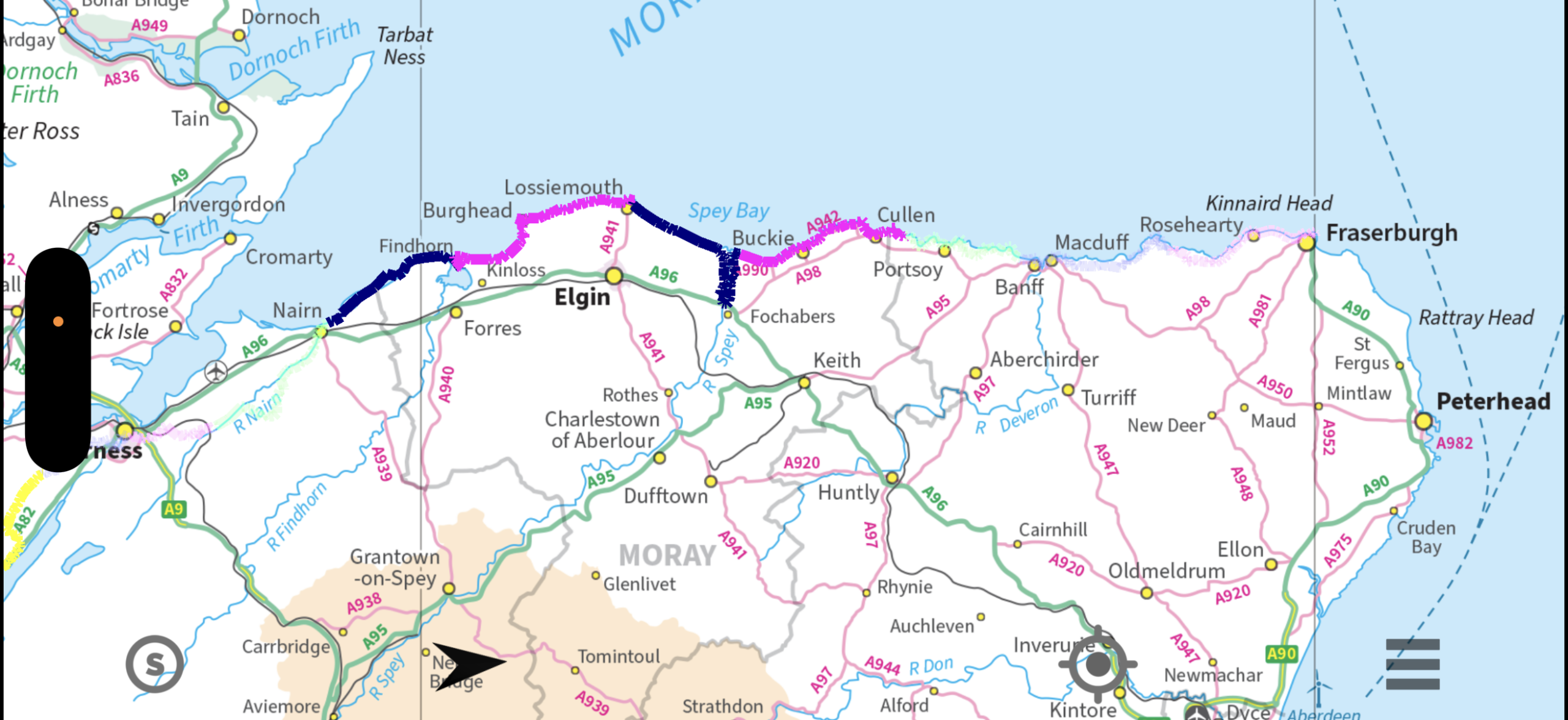
In fact, a lot of it goes along the Moray Coast, an east-west stretch of beach and cliff running from Inverness at the apex of the Moray Firth to Fraserburgh on the North Sea. When I first walked there in 2016 it was to see where the first rehearsals for the D-day invasion were held, and also see remnant World War II defenses. (You’ll hear more about both, I suspect.) Plus, who wouldn’t want to walk on 30 miles of beach again?
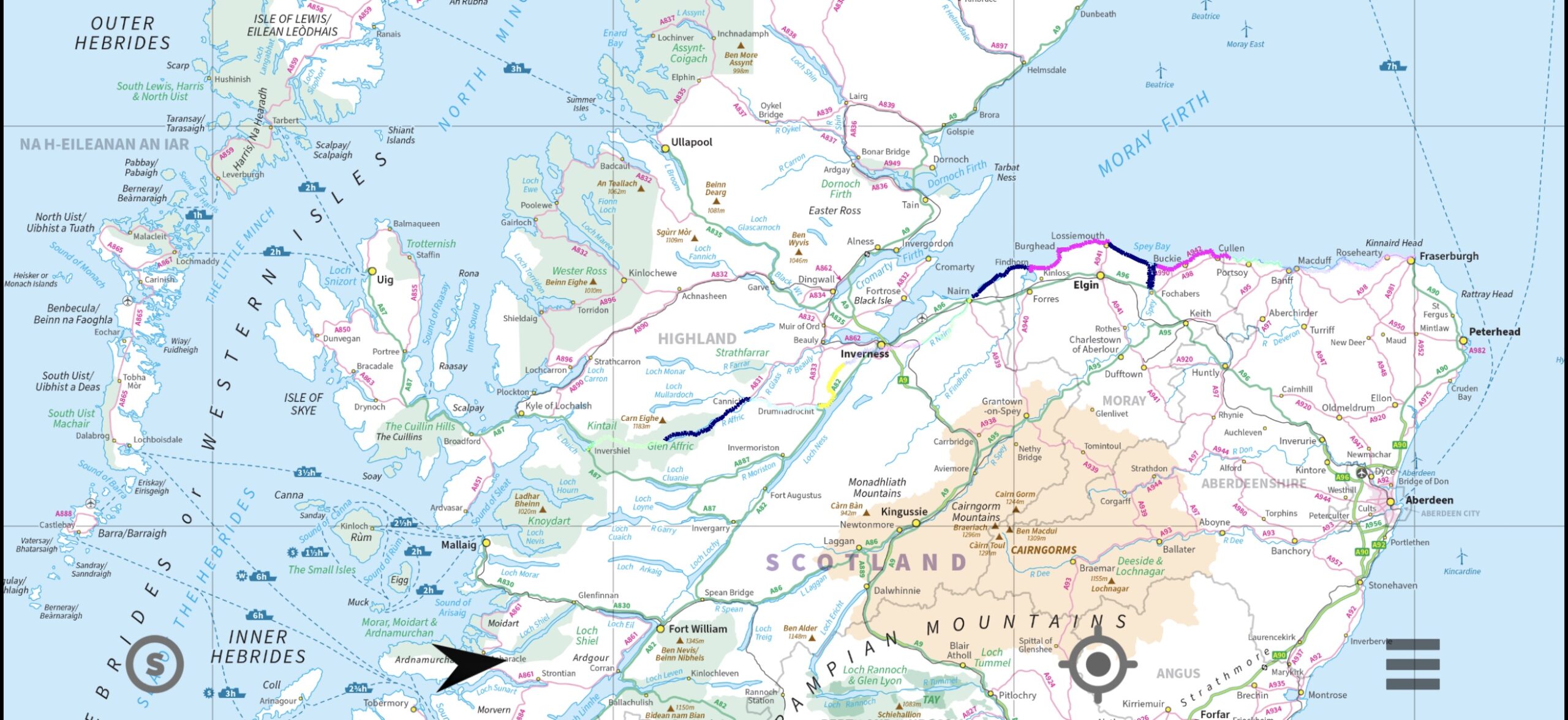
The event requires walking from the west coast to the east coast of the country. But as the maps below show, the definition of “west coast” is flexible. I’m starting in Shiel Bridge, one of the more popular of the dozen designated starting places. It’s on the water, but there is a lot of land to the west of it.
Shiel Bridge is on a “sea loch,” which is essentially a fiord (or if you’re in medicine, an invagination) of the Atlantic Ocean. There are many of these and they extend far inland. I was surprised on one of my early crossings to walk eastward for a day and camp next to what looked like a lake, only to find it had salt water and seaweed.
The first map shows my whole route. I charted it with different colors for different days, some of which are translucent and nearly impossible to see unless you blow the image up. I’ve spent more than two hours trying to change the color of the route to a bold blue for this post. I haven’t been able to and have given up.
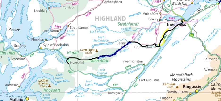
The second map shows the Highland portion of this walk; there isn’t a lot. The third map shows the route from Inverness to Fraserburgh.
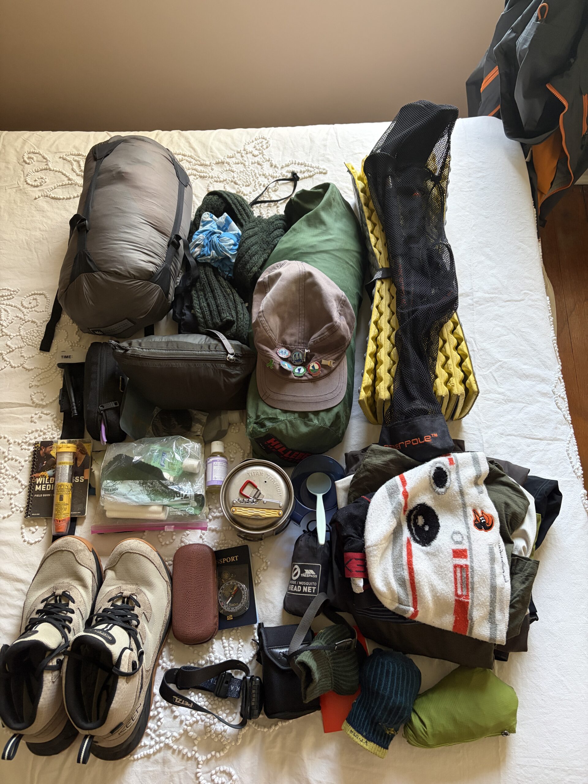
I’m carrying a lot of stuff. This has been a chronic problem. On my second crossing I walked for a day with a paving contractor named Stevie. He was taciturn and tough, but over the course of a day we became trail friends.
He was usually ahead of me, but I caught up with him at a mid-afternoon rest stop, which I left before him because I told him I was so slow and I needed to “crack on,” as they say.
“Yeah, I know,” he said, lying on the ground with his boots off. “You go’ qui’e a bi’ ki’ ”—You got quite a big kit. Which means: “You’re carrying too much stuff.”
This is most of my kit for this crossing. It doesn’t seem excessive. Two tee shirts, two pairs of underpants, two pairs of socks, two pairs of trousers (one a waterproof, as they say), one pair of long underwear, etc. I have mittens, because if you think you’ll need gloves you should bring mittens. I’m bringing a small pair of binoculars—Challengers have laughed at this indulgence—but decided at the last minute to leave the small thermos behind. That was maybe not a good idea, as a thermos was the gateway to the most memorable 30 minutes of my Challenges.
That was an interview with 91-year-old Challenger Jim Taylor about his time in the RAF in World War II, and how he had to go to the doctor to get a bigger shirt after gaining weight during training. (He’d gotten enough to eat for the first time in years.) Jim was famously taciturn, but I offered him a cup of tea from my thermos as he took a break, and he talked. This is a picture of him; you can read his story in the section of this website “Scotland 1 “Jim Taylor’s Story.’

I weighed two scarves on my kitchen scale and picked the lightest. I weighed two spoons and picked the lightest. Nevertheless, the pack weighed 35 pounds at Icelandair check-in—and that was minus the freeze-dried food I had sent to the hotel in Glasgow and the electronics I carried onto the plane because I was still using them.
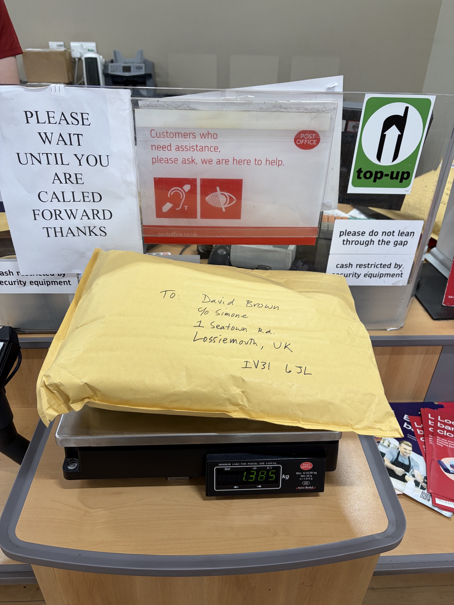
The big tasks today were getting stove fuel (you can’t fly with butane canisters), a cigarette lighter, and mailing three packages of food to places I hope to reach.
Also a bottle of single malt, decanted into a Nalgene.
Tomorrow I get up early to take a 3 1/2 hour train trip to Inverness, and then a 1 1/2 hour bus ride to Shiel Bridge.
We’ll see what happens after that.
Good on you for bringing the binoculars. We readers will enjoy what you see. Crack on!